Free Shipping in Continental USA & Canada -
No Extra fees
LOGIN
EN |
FR
FRANCAIS
$
FORMATS & PRICES
ART GALLERY
ABOUT US
TOOLS
SUPPORT
PRO & ARTISTS
CONTACT US
HOME
COLLECTION
SCENIC
AI WALL ART GENERATOR
LIFESTYLE
BEST SELLERS
LANDSCAPES
VINTAGE POSTERS
1X COLLECTION
BOTANICAL
MINIMALISM
OLD MASTERS & POPULAR PAINTING
WILDLIFE
CITYSCAPES
TYPOGRAPHY
POP
STYLES
ABSTRACT
AI
AIGALLERY
DRAWINGS-ABSTRACT
DRAWINGS-FINEART
DRAWINGS-GRAFFITI
DRAWINGS-ILLUSTRATION
PAINTING
PHOTOGRAPHY-ABSTRACT
PHOTOGRAPHY-LANDSCAPE
PHOTOGRAPHY-PORTRAIT
PHOTOGRAPHY-SURREALISM
VINTAGE-POSTERS
FEATURED
BEST SELLERS
EXPLORE
ROOMS
Bar
Basement
Bathroom
Bedroom
Dining Room
Game Room
Garage
Gym
Hallway
Kid's room
Kitchen
Living room
Nursery
Office
ARTISTS
SELL YOUR ART
MY CART
View Cart
Checkout
COLLECTION
STYLES
FEATURED
TOP SALES
EXPLORE
ROOMS
ARTISTS
SELL
SCENIC
AI WALL ART GENERATOR
LIFESTYLE
BEST SELLERS
LANDSCAPES
VINTAGE POSTERS
1X COLLECTION
BOTANICAL
MINIMALISM
OLD MASTERS & POPULAR PAINTING
WILDLIFE
CITYSCAPES
TYPOGRAPHY
POP
Bar
Basement
Bathroom
Bedroom
Dining Room
Game Room
Garage
Gym
Hallway
Kid's room
Kitchen
Living room
Nursery
Office
ABSTRACT
AI
AIGALLERY
DRAWINGS-ABSTRACT
DRAWINGS-FINEART
DRAWINGS-GRAFFITI
DRAWINGS-ILLUSTRATION
PAINTING
PHOTOGRAPHY-ABSTRACT
PHOTOGRAPHY-LANDSCAPE
PHOTOGRAPHY-PORTRAIT
PHOTOGRAPHY-SURREALISM
VINTAGE-POSTERS
Collection
by Style
by Shape
by Color
by Room
Artists
COLLECTION
Scenic
AI Wall Art Generator
Lifestyle
Best Sellers
Landscapes
Vintage Posters
1X Collection
Botanical
Minimalism
Old Masters & Popular painting
Wildlife
Cityscapes
Typography
Pop
Filter by Style
Abstract
(119.2k)
Ai
(84.2k)
AIGALLERY
(29.2k)
drawings-abstract
(19.5k)
drawings-fineart
(25k)
drawings-graffiti
(2.6k)
drawings-illustration
(57.8k)
painting
(232k)
photography-abstract
(38.4k)
photography-landscape
(306.9k)
photography-portrait
(38.2k)
photography-surrealism
(21.3k)
Vintage-Posters
(51k)
Filter by Shape
Landscape
Panoramic
Vertical
Square
Filter by Color
Filter by Room
Bar
Basement
Bathroom
Bedroom
Dining Room
Game Room
Garage
Gym
Hallway
Kid's room
Kitchen
Living room
Nursery
Office
Art Selection for Resellers
sort by:
Featured
Most Popular
Most Liked
Most Recent
Keyword: strategic-thinking
×
11
Weathered Bishops Crown
Dream World Images
6
1945 Target Map of Katena Area Okinawa – WWII Military Intelligence Chart Used by Allied Forces to Identify Strategic Bombing and Landing Zones in the Final Assault on the Japanese Home Front
History In Your Home
1944 Map of Rhodes – World War II Era Map Depicting the Greek Island Coastal Towns Roads and Strategic Points Reflecting Military Geography Allied Operations and the Strategic Importance of the Aegean Sea During WWII
History In Your Home
1944 WWII Map of the Solomon Islands – Strategic Pacific Theater Map Used During the Allied Campaigns Against Japanese Forces in Key Island Battles of World War Two
History In Your Home
B-52 Stratofortress: Strategic Carpet Bombing Illustration II
ArtDreams92
1965 Cold War-Era Map of Afghanistan – Strategic Survey Depicting Topography Provinces and Political Borders in the Pre-Soviet Invasion Period
History In Your Home
6
1948 IDF Military Map – Strategic Map Depicting Israeli Defense Forces Campaigns Battle Zones and Arab-Israeli War Frontlines During the War of Independence
History In Your Home
1989 Military Base Map of the United States Showing Strategic Air Command Locations Naval Installations and Cold War Military Infrastructure Nationwide
History In Your Home
1920 British Admiralty Map of Pearl Harbor – Early 20th Century Naval Chart Depicting Oahu’s Coastline Harbor Depths and Strategic Military Installations Before the Attack on Pearl Harbor
History In Your Home
1590 English Military Fortification Plan Defending Against the Spanish Armada Along the Coast of Flanders During the Anglo-Spanish War With Strategic Shoreline Batteries
History In Your Home
1942 Military Map of Tripoli Depicting Strategic Locations Streets and Defenses During the North African Campaign of World War II
History In Your Home
1941 Map of Kuwait – Military Map Depicting Borders Towns and Strategic Locations Issued During the Anglo-Iraqi War Reflecting British Military Planning Regional Politics and the Strategic Importance of Kuwait in WWII
History In Your Home
1776 British Map of Newport Rhode Island – Revolutionary War Military Chart Commissioned Before British Occupation Rare Strategic Colonial Map from the American War for Independence
History In Your Home
1985 ROTC Map of America – Cold War Era Training Map of U.S. Military Regions and Command Centers Depicting Strategic Defense and Reserve Officer Program Structure Nationwide
History In Your Home
6
1945 WW2 Battlefield Map of Okinawa – Strategic Allied Invasion Map from Final Pacific Campaign Detailing Terrain Enemy Positions and Combat Objectives in Battle of Okinawa
History In Your Home
6
1940 German Military Map of the Air War – Strategic Luftwaffe Operations Map Highlighting Aerial Combat Zones Bombing Targets and Air Routes During the Early Blitzkrieg Campaigns of WWII
History In Your Home
7
1956 NATO Command Map – Cold War-Era Chart Outlining Military Sectors Regional Divisions and Strategic Jurisdictions of NATO Forces Across Europe and North America During Heightened Tensions
History In Your Home
B-52 Stratofortress: Strategic Global Power Illustration II
ArtDreams92
The Obsidian Sovereign Strategic Mastery
el mehdi agriba
1917 WWI Bombing Map of London – German Zeppelin Air Raid Targets and Damage Zones in London During the First World Wars Early Strategic Bombing Campaigns on Civilian Populations
History In Your Home
The Strategic Duel of Icons | Ultra-Premium Metal & Acrylic Wall Art
Auralis Noctua
B-1 Lancer Strategic Bomber: Fine Art Technical Sketch I
ArtDreams92
B-52 Stratofortress: Strategic Global Power Illustration I
ArtDreams92
12
Fort Knox Hallway
Blaine Stoner
Strategic Location
Deb Oppermann
1936 Italian Map of East Africa – Colonial-Era Map Depicting Eritrea Ethiopia and Italian Somaliland Reflecting Italian Imperial Expansion Regional Geography and Strategic Interests in the Horn of Africa During the Interwar Period
History In Your Home
1939 Map of Sicily Depicting Italian Provinces Coastal Ports Inland Cities Transportation Routes and Strategic Features Prior to the Islands Involvement in World War II Mediterranean Campaigns
History In Your Home
1918 Military Map of Northern Sinai and Palestine Showing Strategic Routes and British Troop Positions During the Palestine Campaign of World War I
History In Your Home
6
War of 1812 American Invasion Map of Canada – Strategic Military Map Detailing U.S. Incursions Fortifications and Battle Routes Along the U.S.–Canada Border During the Anglo-American Conflict
History In Your Home
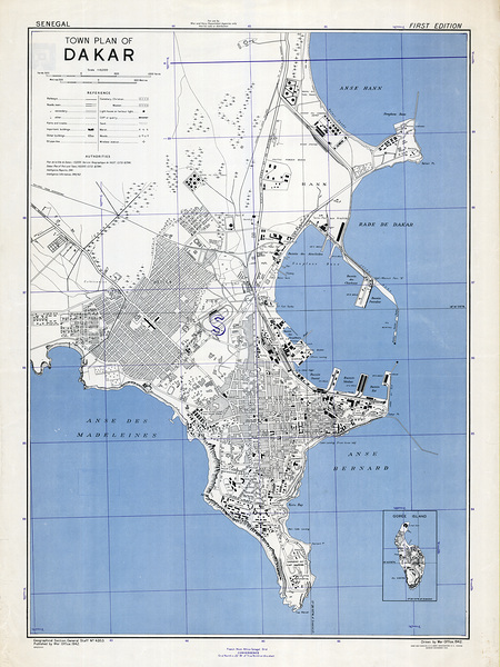
1942 Map of Dakar Senegal – World War II-Era Map Depicting City Streets Harbors and Military Zones Reflecting Strategic Importance of West Africa During the Conflict and Colonial French Administration
History In Your Home
1940 German Military Map of the Battle of Britain – Luftwaffe Strategic Targeting Map Showing Airfields Radar Installations and British Defenses During the First Major Air Campaign of WWII
History In Your Home
1944 Pictorial US Navy Map of the Pacific Theater Depicting Battles Naval Routes Island Campaigns and Strategic Sites Across the Pacific Ocean During the War Against Imperial Japan
History In Your Home
1711 Map of the Battle of Stanileşti – Early 18th-Century Military Map Detailing the Pruth River Campaign Between Ottoman and Russian Forces Including Troop Movements River Crossings Fortifications and Strategic Geography
History In Your Home
6
1990 Map of the Republic of Yemen – Unification-Era Map Showing North and South Yemen Combined with Borders Cities and Strategic Geography
History In Your Home
1914 Map of Alexandria Egypt Showing the Harbor British-Controlled Streets Rail Lines and City Layout on the Eve of World War I as Alexandria Became a Strategic Colonial Port
History In Your Home
1904 Russo-Japanese War Map of Manchuria and Korea – Strategic Military Map Showing Battlefronts Railroads and Geography of the Far East Conflict Between Imperial Japan and Tsarist Russia
History In Your Home
1935 Map of Manchukuo – Japanese Colonial-Era Map Depicting Provinces Cities Railroads Rivers and Strategic Locations Reflecting Imperial Administration Economic Planning and Political Geography in Northeast China
History In Your Home
6
1944 Secret Bigot Map of Omaha Beach – Ultra-Classified Allied Invasion Chart Used to Plan D-Day Assault in Normandy Detailing Defenses Terrain and Target Zones for Operation Overlord
History In Your Home
1918 Map of the Battle of Saint-Mihiel – Vintage WWI Map Depicting Trenches Troop Movements and Strategic Positions in the First Major U.S.-Led Offensive on the Western Front in France
History In Your Home
1810 Map of Suriname Depicting Dutch Colonial Plantations River Systems and Strategic Fortifications During the Height of Transatlantic Trade in Northern South America
History In Your Home
1941 German Military Operation Barbarossa Invasion Map of the Soviet Union – Detailed World War II Map Illustrating German Invasion Routes Soviet Territories Cities Railways Strategic Objectives and Military Movements
History In Your Home
brawl stars
bestshop
Print One
Plant One
One tree planted for every print.
Pictorem supports Trees for the Future, a 501(c)3 non-profit organization, that operates an agroforesty program to restore trees to degraded lands by working with smallholder farmers.
MORE INFO
Proudly
Canadian
Built with Skill, Backed by Community
EMAIL
PASSWORD
CREATE AN ACCOUNT
FORGOT YOUR PASSWORD?
×
CREATE ACCOUNT
USERNAME
EMAIL
PASSWORD
CONFIRM PASSWORD
ALREADY HAVE AN ACCOUNT?
FORGOT YOUR USER ACCOUNT DETAILS?
USERNAME OR EMAIL
AAH, WAIT, I REMEMBER NOW!
×
TOP
Send
Please wait...