Free Shipping in Continental USA & Canada -
No Extra fees
LOGIN
EN |
FR
FRANCAIS
$
FORMATS & PRICES
ART GALLERY
ABOUT US
TOOLS
SUPPORT
PRO & ARTISTS
CONTACT US
HOME
COLLECTION
SCENIC
AI WALL ART GENERATOR
LIFESTYLE
BEST SELLERS
LANDSCAPES
VINTAGE POSTERS
1X COLLECTION
BOTANICAL
MINIMALISM
OLD MASTERS & POPULAR PAINTING
WILDLIFE
CITYSCAPES
TYPOGRAPHY
POP
STYLES
ABSTRACT
AI
AIGALLERY
DRAWINGS-ABSTRACT
DRAWINGS-FINEART
DRAWINGS-GRAFFITI
DRAWINGS-ILLUSTRATION
PAINTING
PHOTOGRAPHY-ABSTRACT
PHOTOGRAPHY-LANDSCAPE
PHOTOGRAPHY-PORTRAIT
PHOTOGRAPHY-SURREALISM
VINTAGE-POSTERS
FEATURED
BEST SELLERS
EXPLORE
ROOMS
Bar
Basement
Bathroom
Bedroom
Dining Room
Game Room
Garage
Gym
Hallway
Kid's room
Kitchen
Living room
Nursery
Office
ARTISTS
SELL YOUR ART
MY CART
View Cart
Checkout
COLLECTION
STYLES
FEATURED
TOP SALES
EXPLORE
ROOMS
ARTISTS
SELL
SCENIC
AI WALL ART GENERATOR
LIFESTYLE
BEST SELLERS
LANDSCAPES
VINTAGE POSTERS
1X COLLECTION
BOTANICAL
MINIMALISM
OLD MASTERS & POPULAR PAINTING
WILDLIFE
CITYSCAPES
TYPOGRAPHY
POP
Bar
Basement
Bathroom
Bedroom
Dining Room
Game Room
Garage
Gym
Hallway
Kid's room
Kitchen
Living room
Nursery
Office
ABSTRACT
AI
AIGALLERY
DRAWINGS-ABSTRACT
DRAWINGS-FINEART
DRAWINGS-GRAFFITI
DRAWINGS-ILLUSTRATION
PAINTING
PHOTOGRAPHY-ABSTRACT
PHOTOGRAPHY-LANDSCAPE
PHOTOGRAPHY-PORTRAIT
PHOTOGRAPHY-SURREALISM
VINTAGE-POSTERS
Collection
by Style
by Shape
by Color
by Room
Artists
COLLECTION
Scenic
AI Wall Art Generator
Lifestyle
Best Sellers
Landscapes
Vintage Posters
1X Collection
Botanical
Minimalism
Old Masters & Popular painting
Wildlife
Cityscapes
Typography
Pop
Filter by Style
Abstract
(119.2k)
Ai
(84.2k)
AIGALLERY
(29.2k)
drawings-abstract
(19.5k)
drawings-fineart
(25k)
drawings-graffiti
(2.6k)
drawings-illustration
(57.8k)
painting
(232k)
photography-abstract
(38.4k)
photography-landscape
(306.9k)
photography-portrait
(38.2k)
photography-surrealism
(21.3k)
Vintage-Posters
(51k)
Filter by Shape
Landscape
Panoramic
Vertical
Square
Filter by Color
Filter by Room
Bar
Basement
Bathroom
Bedroom
Dining Room
Game Room
Garage
Gym
Hallway
Kid's room
Kitchen
Living room
Nursery
Office
Art Selection for Resellers
sort by:
Featured
Most Popular
Most Liked
Most Recent
Keyword: railroads
×
American Railroads - Life line of the nation
1x
6
1930 Road Map of Ventura County California – Vintage Early 20th Century Highway and Route Map Featuring Towns Railroads and Coastal Geography in Southern California
History In Your Home
1916 Map of Santa Cruz County California Displaying Township Divisions Railroads Natural Features and Early 20th-Century Urban and Agricultural Development in the Central Coast Region
History In Your Home
1888 Map of Los Angeles County California Showing Township Boundaries Railroads and Settlements During a Period of Rapid Expansion in Southern California
History In Your Home
6
1925 Map of Memphis Tennessee – Vintage Early 20th Century Southern City Map Depicting Streets Railroads Riverfront and Neighborhoods Along the Mississippi River
History In Your Home
1878 Map of Oakland Berkeley and Alameda California – Vintage Bay Area City Planning Map Depicting Streets Railroads Land Plots and Waterfronts in Late 19th Century East Bay Development
History In Your Home
6
1894 Map of Fort Worth Texas – Vintage Cartographic Reproduction of the “Queen City of the Prairies” Showing Streets Railroads Landmarks and Urban Development in 19th Century Texas
History In Your Home
6
1890 Map of the City of Denver Colorado – Historic Urban Cartography of the Mile High City | Vintage 19th Century Map Featuring Streets Railroads & City Blocks
History In Your Home
1906 Map of Stanislaus County California – Vintage Agricultural Region Map | Historic Central Valley Cartography Featuring Towns Railroads and Land Division in Early 20th Century California
History In Your Home
6
1896 Map of Long Island New York – Late 19th Century Map Detailing Counties Towns Railroads and Coastline During a Period of Suburban Growth and Industrial Expansion in the Northeast
History In Your Home
1917 Map of Arkansas Showing County Lines Railroads and Geographic Features During Early 20th Century State Development
History In Your Home
1930 Map of Charlotte North Carolina – Vintage Pre-War City Map Depicting Streets Railroads Neighborhoods and Urban Development in the Queen City of the American South
History In Your Home
Norfolk Southern Train in Appalachian Mountains Southwest Virginia
Shelia Hunt Photography
Historic Southern Railway Terminal
Shelia Hunt Photography
DSC4335
Dave Reede Photohgraphy
1898 Map of Indianapolis – Detailed 19th Century Map Showing Streets Districts Landmarks Railroads and Urban Growth of Indianapolis Indiana During the Late Gilded Age
History In Your Home
6
1912 Map of Arizona Showing Counties Railroads and Geographic Features Shortly Before Statehood in the Early 20th Century
History In Your Home
1850 Map of New Jersey – Mid-19th Century Map Depicting Counties Railroads and Coastal Cities in the Industrial Era of the Northeastern United States
History In Your Home
1889 Map of Atlanta Georgia – Late 19th-Century Urban Map Depicting Streets Railroads Districts and Landmarks Reflecting Post-Reconstruction Growth Industrial Expansion and the Emerging Metropolitan Landscape of the South
History In Your Home
1890 Map of Fairhaven Neighborhood in Washington – Late 19th-Century City Plan Depicting Streets Railroads Property Divisions and Coastal Layout Reflecting Urban Expansion Real Estate Development and Early American City Planning
History In Your Home
1914 Map of South San Francisco Bay Area Showing Urban Development Railroads and Geographic Features Prior to World War I
History In Your Home
1887 Bird’s Eye View of Auburn California – Historic Gold Rush-Era Pictorial Map Featuring Railroads Streets and Buildings in a Key Sierra Foothills Town of the American West
History In Your Home
6
1896 Map of Cripple Creek Colorado – Detailed Survey of the Gold Mining District Showing Mining Claims Railroads and Geological Features During Colorado’s Late 19th Century Gold Rush Era
History In Your Home
6
1925 Map of Lakeland Florida – Early 20th Century Florida City Map Showing Streets Railroads Lakes and Real Estate Developments During Florida’s Land Boom
History In Your Home
7
Historic Southern Railway Terminal Black and White Photography Knoxville Tennessee
Shelia Hunt Photography
Historical Map of Oakland California Showing Urban Expansion Railroads and Infrastructure During the Early 20th Century Bay Area Industrial and Port Development
History In Your Home
DSC0763
Dave Reede Photohgraphy
1899 Map of Idaho – Late 19th Century State Map Showing Counties Railroads Mining Districts Rivers Towns Timber Regions Mountain Ranges and Key Geographic Features of Idaho at the Turn of the Century
History In Your Home
6
1913 Map of Canada Published by the Canadian Department of the Interior Showing Provinces Territories Railroads and Natural Resources
History In Your Home
1904 Map of Bolivia – Early 20th-Century National Map Showing Department Boundaries Mountain Ranges Rivers Cities Railroads and Topographical Features Across Bolivia During the Post-War Territorial Consolidation Period
History In Your Home
1872 Map of Chicago Illinois – Post-Fire Reconstruction Map Depicting Streets Railroads and Lakefront Development Reflecting the City’s Rapid Growth Industrial Progress and Rebuilding After the Great Chicago Fire
History In Your Home
1904 Map of Oregon – Early 20th Century State Map Showing Counties Railroads Rivers and Settlements Capturing Oregon’s Development During the Era of Expansion and the Rise of the Pacific Northwest
History In Your Home
1917 Map of Nashville Tennessee Showing City Streets Railroads and Key Buildings During the World War I Era as the City Grew as a Transportation and Industrial Hub
History In Your Home
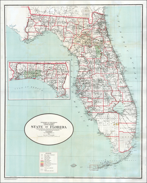
1923 General Land Office Map of Florida – Official U.S. Government Map Showing Counties Railroads Public Lands and Swamp Drainage Projects During the Florida Real Estate Boom of the 1920s
History In Your Home
6
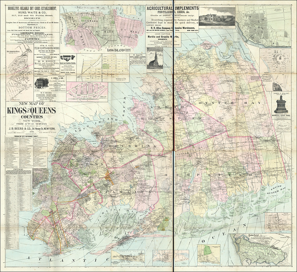
1886 Map of Kings and Queens Counties New York – Historic Gilded Age Map Detailing Brooklyn and Long Island Townships Roads Railroads and Early Urban Development in 19th Century NYC
History In Your Home
1891 Map of Minneapolis Minnesota Featuring Bridges Railroads Parks and Public Buildings as the Twin Cities Emerged as a Key Industrial and Commercial Center of the Upper Midwest
History In Your Home
6
1928 Map of Atlanta Georgia – Vintage Early 20th Century City Map Depicting Streets Railroads Neighborhoods and Urban Expansion in the Growing Capital of the New South
History In Your Home
1906 Map of Coos Bay Oregon Showing Harbor Infrastructure Railroads and Development Plans During the Logging and Shipping Boom of the Early 20th Century Pacific Northwest
History In Your Home
DSC2487 done
Dave Reede Photohgraphy
1913 Map of Saskatchewan Canada Showing Railroads Townships and Settler Land Distribution in the Early 20th Century Prairie Provinces
History In Your Home
Map of Anchorage Alaska – Detailed City and Regional Map Showing Anchorage Layout Railroads Road Networks Coastal Geography Mountain Ranges Rivers Urban Districts and Alaska’s Natural Landscape Features
History In Your Home
1909 Map of Chicago Illinois – Early 20th-Century Urban Map Depicting Railroads Parks and Lakefront Development Reflecting the City’s Industrial Growth Architectural Expansion and Role as a Commercial Hub of the Midwest
History In Your Home
Print One
Plant One
One tree planted for every print.
Pictorem supports Trees for the Future, a 501(c)3 non-profit organization, that operates an agroforesty program to restore trees to degraded lands by working with smallholder farmers.
MORE INFO
EMAIL
PASSWORD
CREATE AN ACCOUNT
FORGOT YOUR PASSWORD?
×
CREATE ACCOUNT
USERNAME
EMAIL
PASSWORD
CONFIRM PASSWORD
ALREADY HAVE AN ACCOUNT?
FORGOT YOUR USER ACCOUNT DETAILS?
USERNAME OR EMAIL
AAH, WAIT, I REMEMBER NOW!
×
TOP
Send
Please wait...