Free Shipping in Continental USA & Canada -
No Extra fees
LOGIN
EN |
FR
FRANCAIS
$
FORMATS & PRICES
ART GALLERY
ABOUT US
TOOLS
SUPPORT
PRO & ARTISTS
CONTACT US
HOME
COLLECTION
SCENIC
AI WALL ART GENERATOR
LIFESTYLE
BEST SELLERS
LANDSCAPES
VINTAGE POSTERS
1X COLLECTION
BOTANICAL
MINIMALISM
OLD MASTERS & POPULAR PAINTING
WILDLIFE
CITYSCAPES
TYPOGRAPHY
POP
STYLES
ABSTRACT
AI
AIGALLERY
DRAWINGS-ABSTRACT
DRAWINGS-FINEART
DRAWINGS-GRAFFITI
DRAWINGS-ILLUSTRATION
PAINTING
PHOTOGRAPHY-ABSTRACT
PHOTOGRAPHY-LANDSCAPE
PHOTOGRAPHY-PORTRAIT
PHOTOGRAPHY-SURREALISM
VINTAGE-POSTERS
FEATURED
BEST SELLERS
EXPLORE
ROOMS
Bar
Basement
Bathroom
Bedroom
Dining Room
Game Room
Garage
Gym
Hallway
Kid's room
Kitchen
Living room
Nursery
Office
ARTISTS
SELL YOUR ART
MY CART
View Cart
Checkout
COLLECTION
STYLES
FEATURED
TOP SALES
EXPLORE
ROOMS
ARTISTS
SELL
SCENIC
AI WALL ART GENERATOR
LIFESTYLE
BEST SELLERS
LANDSCAPES
VINTAGE POSTERS
1X COLLECTION
BOTANICAL
MINIMALISM
OLD MASTERS & POPULAR PAINTING
WILDLIFE
CITYSCAPES
TYPOGRAPHY
POP
Bar
Basement
Bathroom
Bedroom
Dining Room
Game Room
Garage
Gym
Hallway
Kid's room
Kitchen
Living room
Nursery
Office
ABSTRACT
AI
AIGALLERY
DRAWINGS-ABSTRACT
DRAWINGS-FINEART
DRAWINGS-GRAFFITI
DRAWINGS-ILLUSTRATION
PAINTING
PHOTOGRAPHY-ABSTRACT
PHOTOGRAPHY-LANDSCAPE
PHOTOGRAPHY-PORTRAIT
PHOTOGRAPHY-SURREALISM
VINTAGE-POSTERS
Collection
by Style
by Shape
by Color
by Room
Artists
COLLECTION
Scenic
AI Wall Art Generator
Lifestyle
Best Sellers
Landscapes
Vintage Posters
1X Collection
Botanical
Minimalism
Old Masters & Popular painting
Wildlife
Cityscapes
Typography
Pop
Filter by Style
Abstract
(119.2k)
Ai
(84.2k)
AIGALLERY
(29.2k)
drawings-abstract
(19.5k)
drawings-fineart
(25k)
drawings-graffiti
(2.6k)
drawings-illustration
(57.8k)
painting
(232k)
photography-abstract
(38.4k)
photography-landscape
(306.9k)
photography-portrait
(38.2k)
photography-surrealism
(21.3k)
Vintage-Posters
(51k)
Filter by Shape
Landscape
Panoramic
Vertical
Square
Filter by Color
Filter by Room
Bar
Basement
Bathroom
Bedroom
Dining Room
Game Room
Garage
Gym
Hallway
Kid's room
Kitchen
Living room
Nursery
Office
Art Selection for Resellers
sort by:
Featured
Most Popular
Most Liked
Most Recent
Keyword: ottoman
×
6
1896 Map of the Ottoman Empire – Strategic Political Survey Depicting the Administrative and Territorial Structure of the Sultanate Just Before the Dawn of the 20th Century
History In Your Home
6
1893 Map of the Ottoman Empire – Late Imperial Survey Showing Administrative Divisions and Political Borders Amidst Decline of One of the Worlds Longest-Lasting Empires in the 19th Century
History In Your Home
1890 Ottoman Turkish Map of Europe – Late 19th Century Imperial Cartography Depicting European Borders Cities and Strategic Interests of the Ottoman Empire
History In Your Home
1875 Ottoman Turkish Map of Central Greece or Thessaly Showing Topography Regional Borders Settlements and Natural Features Prior to the Region’s Annexation by Modern Greece
History In Your Home
1714 Henri Chatelain Map of the Ottoman Empire – Decorative Enlightenment-Era Cartographic Masterpiece Illustrating the Vast Reach of the Sultan’s Territories in Europe Asia and Africa
History In Your Home
1891 Ottoman Military Map of Crete Depicting Forts Mountain Terrain Settlements and Strategic Locations as the Empire Responded to Revolts and Greek Nationalist Uprisings
History In Your Home
6
1830 Map of Istanbul Turkey – Historic Ottoman Empire Cartography Reproduction | 19th Century Constantinople Map Featuring the Bosphorus Districts & Landmarks
History In Your Home
1895 Map of Ottoman Lebanon Showing Administrative Divisions Mountain Settlements and Religious Communities Under Late 19th Century Turkish Imperial Rule
History In Your Home
1897 Ottoman Turkish Map of Ioannina Greece Showing City Layout Fortresses and Administrative Districts During the Greco-Turkish War
History In Your Home
1918 Ottoman Turkish Map of Palestine – Late Ottoman-Era Map Depicting Geographic Divisions and Settlements in the Holy Land During World War I and the Decline of Ottoman Rule
History In Your Home
1559 Hajji Ahmed World Map – Ottoman Turkish Cordiform Map Printed in Venice with Early Islamic Geography & Detailed Global Depiction
History In Your Home
1910 Ottoman Survey Map of the Iraq–Iran Border – Detailed Regional Map Depicting Settlements Rivers and Terrain Reflecting Late Ottoman Administrative Geography and Early 20th-Century Political Boundaries in the Middle East
History In Your Home
1910 Ottoman Turkish Map of Mesopotamia – Early 20th Century Ottoman Cartographic Work Depicting the Region Between the Tigris and Euphrates Rivers Including Baghdad Basra and Ancient Sites
History In Your Home
1928 Ottoman Turkish Map of the Middle East – Late Ottoman Era Map Depicting Key Regions Including Syria Iraq Palestine and Arabia Reflecting Political Changes After World War I and Empire Dissolution
History In Your Home
Pictorial Map of the Ottoman Empire – Decorative Historical Illustration Depicting the Extent of Ottoman Territories Across Europe Asia and Africa with Cultural and Political Annotations
History In Your Home
1890 Map of Tripoli Depicting Ottoman Administrative Districts Mediterranean Fortifications and Urban Layout During Late Imperial Rule in Present-Day Libya
History In Your Home
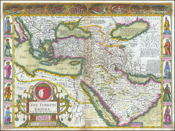
1626 Map of the Ottoman Empire – John Speed’s Historic Early 17th Century Map Depicting Turkish Dominions Across Europe Asia and North Africa with Decorative Borders
History In Your Home
1905 Ottoman Military Map of Armenia – Early 20th Century Strategic Map Depicting Key Armenian Regions Under Ottoman Administration Before the Fall of the Empire
History In Your Home
39
Ali Pasha and Kira Vassiliki by Paul Emil Jacobs Classical Fine Art Xzendor7 Old Masters Reproductions
xzendor7
1875 Ottoman Turkish Map of Montenegro Depicting the Rugged Balkan Terrain Strategic Settlements and Borders During a Period of Rising Nationalism and Decline of Ottoman Control in Southeastern Europe
History In Your Home
1882 Map of Istanbul Turkey – Ottoman-Era Map Depicting Constantinople’s Streets Mosques and Landmarks Across the Bosphorus Reflecting the Imperial City’s Late 19th Century Transformation
History In Your Home
1852 Ottoman Turkish Map of Istanbul – Detailed 19th Century Map Depicting the Imperial City of Constantinople with Mosques Districts and the Bosphorus Strait During Ottoman Rule
History In Your Home
1901 Topographical and Physical Map of Palestine Showing Mountains Rivers and Historical Sites During the Late Ottoman Era in the Holy Land
History In Your Home
Map of the Turkish War of Independence – Vintage Post-Ottoman Cartographic Reproduction Highlighting Anatolian Battlefronts Greek Invasion Routes and Turkish Nationalist Forces from 1919 to 1923
History In Your Home
18th Century View of Istanbul Turkey – Panoramic Engraving of Constantinople Depicting the Bosphorus Hagia Sophia and Ottoman Architecture Capturing the Cultural and Maritime Heart of the Ottoman Empire
History In Your Home
Pictorial Map of Vienna During the First Turkish Siege in 1529 – Illustrated Historical Map Showing Ottoman Siege Lines City Walls Artillery Positions Key Landmarks Defensive Works and the Dramatic Struggle for Habsburg Vienna
History In Your Home
1897 Ottoman Turkish Map of the Arabian Peninsula and Red Sea Depicting Pilgrimage Routes Tribal Territories and Important Port Cities at the Height of Ottoman Influence in the Islamic World
History In Your Home
1905 Ottoman Turkish Map of the Balkans Depicting Territorial Boundaries Ethnic Regions and Strategic Cities Prior to the Balkan Wars That Preceded the Collapse of Ottoman Influence in Southeastern Europe
History In Your Home
1592 Map of the Ottoman Empire by Abraham Ortelius – Renaissance Map Depicting Turkey the Balkans North Africa and the Eastern Mediterranean Reflecting European Understanding of Ottoman Geography and Political Domains
History In Your Home
1911 Ottoman Turkish Map of the Levant – Detailed Map Depicting Provinces Cities Rivers Roads and Political Boundaries Reflecting Ottoman Administration Geographic Knowledge and Historical Context of the Eastern Mediterranean
History In Your Home
12
1911 Military Map of the Italo-Turkish War – Early 20th Century Conflict Map Depicting Italian and Ottoman Military Positions in Libya and the Mediterranean During Imperial Expansion
History In Your Home
17th Century Ottoman Turkish Map of the Sea of Marmara the Bosphorus and the Dardanelles – Early Map Depicting Coastal Fortifications Harbors and Trade Routes Reflecting Ottoman Naval Geography and Strategic Waterways
History In Your Home
6
1843 Map of Syria – Historic Ottoman-Era Cartographic Depiction of 19th Century Syria Showing Cities Regions & Borders Under Turkish Control Before Modern Middle Eastern Boundaries Were Established
History In Your Home
1922 Map of Istanbul Turkey – Early 20th Century Map of Post-Ottoman Constantinople Depicting Districts the Golden Horn and Bosphorus Following the End of the Ottoman Empire
History In Your Home
6
1904 Map of Lebanon Depicting Ottoman-Era Administrative Divisions and Coastal Geography Prior to French Mandate Rule in the Middle East
History In Your Home
1917 Map of Palestine Depicting Ottoman-Era Territories and Strategic Military Zones During the Final Year of World War I in the Middle East
History In Your Home
1830 Map of Istanbul Turkey – Ottoman Era Map Depicting Constantinople the Golden Horn and Bosphorus Strait Showing Palaces Mosques and Historic Districts of the Imperial Capital
History In Your Home
1917 Ottoman Turkish Map of the Sinai and Palestine Campaign Depicting World War I Military Operations Front Lines Railways and Strategic Positions in the Middle Eastern Theater
History In Your Home
1698 View of Constantinople – Late 17th Century Pictorial Map of Istanbul Showing City Layout Golden Horn Mosques Landmarks Topography and Ottoman Urban Planning
History In Your Home
Dolmabahce sarayi Ottoman sultans palace in Istanbul Turkey
Gvantsa Barkaia
91
Albanian Muslim Flag of the Ottoman Empire
Fun With Flags
6
WOODEN OTTOMAN HOUSE
Gualtiero Boffi
Print One
Plant One
One tree planted for every print.
Pictorem supports Trees for the Future, a 501(c)3 non-profit organization, that operates an agroforesty program to restore trees to degraded lands by working with smallholder farmers.
MORE INFO
EMAIL
PASSWORD
CREATE AN ACCOUNT
FORGOT YOUR PASSWORD?
×
CREATE ACCOUNT
USERNAME
EMAIL
PASSWORD
CONFIRM PASSWORD
ALREADY HAVE AN ACCOUNT?
FORGOT YOUR USER ACCOUNT DETAILS?
USERNAME OR EMAIL
AAH, WAIT, I REMEMBER NOW!
×
TOP
Send
Please wait...