Free Shipping in Continental USA & Canada -
No Extra fees
LOGIN
EN |
FR
FRANCAIS
$
FORMATS & PRICES
ART GALLERY
ABOUT US
TOOLS
SUPPORT
PRO & ARTISTS
CONTACT US
HOME
COLLECTION
SCENIC
AI WALL ART GENERATOR
LIFESTYLE
BEST SELLERS
LANDSCAPES
VINTAGE POSTERS
1X COLLECTION
BOTANICAL
MINIMALISM
OLD MASTERS & POPULAR PAINTING
WILDLIFE
CITYSCAPES
TYPOGRAPHY
POP
STYLES
ABSTRACT
AI
AIGALLERY
DRAWINGS-ABSTRACT
DRAWINGS-FINEART
DRAWINGS-GRAFFITI
DRAWINGS-ILLUSTRATION
PAINTING
PHOTOGRAPHY-ABSTRACT
PHOTOGRAPHY-LANDSCAPE
PHOTOGRAPHY-PORTRAIT
PHOTOGRAPHY-SURREALISM
VINTAGE-POSTERS
FEATURED
BEST SELLERS
EXPLORE
ROOMS
Bar
Basement
Bathroom
Bedroom
Dining Room
Game Room
Garage
Gym
Hallway
Kid's room
Kitchen
Living room
Nursery
Office
ARTISTS
SELL YOUR ART
MY CART
View Cart
Checkout
COLLECTION
STYLES
FEATURED
TOP SALES
EXPLORE
ROOMS
ARTISTS
SELL
SCENIC
AI WALL ART GENERATOR
LIFESTYLE
BEST SELLERS
LANDSCAPES
VINTAGE POSTERS
1X COLLECTION
BOTANICAL
MINIMALISM
OLD MASTERS & POPULAR PAINTING
WILDLIFE
CITYSCAPES
TYPOGRAPHY
POP
Bar
Basement
Bathroom
Bedroom
Dining Room
Game Room
Garage
Gym
Hallway
Kid's room
Kitchen
Living room
Nursery
Office
ABSTRACT
AI
AIGALLERY
DRAWINGS-ABSTRACT
DRAWINGS-FINEART
DRAWINGS-GRAFFITI
DRAWINGS-ILLUSTRATION
PAINTING
PHOTOGRAPHY-ABSTRACT
PHOTOGRAPHY-LANDSCAPE
PHOTOGRAPHY-PORTRAIT
PHOTOGRAPHY-SURREALISM
VINTAGE-POSTERS
Collection
by Style
by Shape
by Color
by Room
Artists
COLLECTION
Scenic
AI Wall Art Generator
Lifestyle
Best Sellers
Landscapes
Vintage Posters
1X Collection
Botanical
Minimalism
Old Masters & Popular painting
Wildlife
Cityscapes
Typography
Pop
Filter by Style
Abstract
(119.2k)
Ai
(84.2k)
AIGALLERY
(29.2k)
drawings-abstract
(19.5k)
drawings-fineart
(25k)
drawings-graffiti
(2.6k)
drawings-illustration
(57.8k)
painting
(232k)
photography-abstract
(38.4k)
photography-landscape
(306.9k)
photography-portrait
(38.2k)
photography-surrealism
(21.3k)
Vintage-Posters
(51k)
Filter by Shape
Landscape
Panoramic
Vertical
Square
Filter by Color
Filter by Room
Bar
Basement
Bathroom
Bedroom
Dining Room
Game Room
Garage
Gym
Hallway
Kid's room
Kitchen
Living room
Nursery
Office
Art Selection for Resellers
sort by:
Featured
Most Popular
Most Liked
Most Recent
Keyword: habsburg
×
54
Habsburg Monarchy Civil Flag
Fun With Flags
1792 Postal Map of the Habsburg Empire – Vintage Imperial-Era Reproduction Showing Roads Cities and Mail Routes Across Central Europe Under Austrian Rule Before the Rise of Nationalism
History In Your Home
1826 Postal Map of the Habsburg Empire – Early 19th Century Transportation and Communication Map Showing Mail Routes Stagecoach Roads and Administrative Centers Across Central Europe
History In Your Home
1828 Map of Budapest Hungary – Early 19th Century Cartographic View of the Twin Cities Buda and Pest Situated Along the Danube River Within the Kingdom of Hungary Under Habsburg Rule
History In Your Home
1690 Map of the Danube Region – Early Modern Map Illustrating the Strategic Importance of the Danube Basin in Ottoman-Habsburg Conflicts and European Trade
History In Your Home
1844 Map of Vienna Austria – Mid-19th Century Map of the Imperial Capital Showing Streets Palaces and Fortifications During the Habsburg Monarchy’s Height of Urban and Cultural Development
History In Your Home
62
Imperial Banner of the Holy Roman Emperor 1430 - 1806
Fun With Flags
The Entry Of King Rudolf Of Habsburg Into Basel In 1273 [1808–1810] by Franz Pforr [1788–1812]
MyCozyFineArt
1810 Map of Vienna – Early 19th Century Austrian City Map Depicting Streets Districts and Landmarks Capturing the Architectural and Cultural Landscape of Imperial Vienna During the Habsburg Era
History In Your Home
1544 Giacomo Gastaldi Map of Spain Depicting Iberian Geography Major Cities Rivers and Regional Divisions During the Renaissance Era Under the Habsburg Monarchy
History In Your Home
12
Map of Europe Under Emperor Charles V – 16th Century Holy Roman Empire Map Showing Imperial Territories European Borders and Political Power in the Age of Reformation
History In Your Home
Portrait Of Archduke Leopold [Later Emperor Leopold Ii] [circa 1765] by Habsburg Court Painter [16th–20th Century]
MyCozyFineArt
1866 Map of Vienna Austria – Austro-Prussian War Era Map Depicting the Imperial Capital’s Streets Fortifications and Landmarks Highlighting Vienna’s Role as the Political and Cultural Center of the Habsburg Empire
History In Your Home
An allegorical scene by Habsburg Court Painter [16th–20th Century]
MyCozyFineArt
1720 Map of the Kingdom of Hungary – Early 18th Century Map Depicting Hungarian Counties Rivers and Borders within the Habsburg Empire Reflecting Central European Geography Politics and Cartography of the Baroque Period
History In Your Home
Allegory of Painting under the House of Habsburg [1619–1620] by Bartholomäus Strobel the younger [1591–1650]
MyCozyFineArt
6
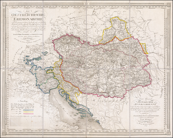
1786 Map of the Austro-Hungarian Empire – Detailed Late 18th Century Map Depicting Imperial Territories Rivers Borders and Administrative Divisions Before the Napoleonic Wars
History In Your Home
Portrait Of Emperor Joseph Ii As A Young Man [1741–1790] by Habsburg Court Painter [16th–20th Century]
MyCozyFineArt
17th Century Map of Madrid Spain – Early Modern City Map Depicting the Streets Palaces and Churches of Spain’s Capital Showcasing Habsburg-Era Urban Planning and the Architectural Heart of Imperial Spain
History In Your Home
1808 Map of Vienna Austria – Detailed Post-Napoleonic-Era Urban Map Showing City Walls Districts Roads Landmarks and Surrounding Countryside During Early 19th-Century Habsburg Imperial Administration
History In Your Home
1680 Map of the Kingdom of Hungary and the Balkan Peninsula – Late 17th-Century Map Depicting Counties Cities Rivers and Borders Reflecting Habsburg Rule Ottoman Influence and Central European Geography
History In Your Home
Radbot. Graf von Habsburg zeigt seinem Bruder Bischof Werner seine bewaffneten Getreuen [1853] by Ferdinand Schubert [1824–1853]
MyCozyFineArt
1799 Map of the Austro-Hungarian Empire – Political and Geographical Map Created Just Before the Turn of the 19th Century Detailing Provinces Roads and Strategic Military Routes
History In Your Home
Rudolf of Habsburg and the priest [1818] by Franz Ludwig Catel [1778–1856]
MyCozyFineArt
1808 Map of the Kingdom of Hungary – Early 19th-Century Habsburg-Era Territorial Map Showing Counties Rivers Cities Political Divisions and Geographic Features Across Historic Central Europe
History In Your Home
View Of Meggen With The Ruin Of Neu–Habsburg by Salomon Brunner [1778–1848]
MyCozyFineArt
1809 Map of the Austrian Empire – Napoleonic-Era Political Map Showing Habsburg Domains Military Strongholds and Imperial Boundaries at the Height of Conflict with Napoleonic France
History In Your Home
Pictorial Map of Vienna During the First Turkish Siege in 1529 – Illustrated Historical Map Showing Ottoman Siege Lines City Walls Artillery Positions Key Landmarks Defensive Works and the Dramatic Struggle for Habsburg Vienna
History In Your Home
A Portrait Of Archduke Albrecht Vii. Governor Of The Spanish Netherlands [1559–1621] [circa 1600] by Habsburg Court Painter [16th–20th Century]
MyCozyFineArt
Rudolf von Habsburg und der Priester [1828] by Ludwig Ferdinand Schnorr von Carolsfeld [1788–1853]
MyCozyFineArt
1792 Map of the Kingdom of Hungary – Detailed Cartographic Depiction of Hungarian Territories Cities Rivers and Mountains Within the Habsburg Monarchy During the Late 18th Century
History In Your Home
1803 Map of Croatia – Early 19th Century Cartography Depicting Political Boundaries Cities and Regional Geography During Habsburg Rule in Central Europe
History In Your Home
Portrait Of Archduke Ernst Of Austria [1553–1595] by Habsburg Court Painter [16th–20th Century]
MyCozyFineArt
Rudolf von Habsburg an der Leiche Přemysl Ottokars. König von Böhmen [before 1854] by Anton Romako [1832–1889]
MyCozyFineArt
1849 Map of the Kingdom of Hungary – Cartographic Record From the Hungarian Revolution of 1848 Showing Cities Roads and Political Boundaries Within the Habsburg-Controlled Region
History In Your Home
Wenzel bittet Rudolf von Habsburg um die Leiche seines Vaters Przemysl Ottokar [1826] by Anton Petter [1781–1858]
MyCozyFineArt
18th Century View of Vienna Austria – Panoramic Engraved City View Depicting Baroque Architecture Palaces and the Danube River During the Habsburg Era Capturing the Cultural Heart of Imperial Europe
History In Your Home
1593 De Jode Map of the Kingdom of Naples Depicting Southern Italy’s Provinces Mountains and Coastal Cities During the Spanish Habsburg Rule in the Late Renaissance
History In Your Home
BW Karlskirche Habsburg Dynasty Baroque Cathedral in Vienna Austria
360 Studios
1712 Herman Moll Map of the Holy Roman Empire – Political Cartography of Central Europe’s Complex Feudal Territories During the Early 18th Century Germanic Confederation
History In Your Home
Reoccupation Of Buda Castle In 1686 by Gyula Benczur Fine Art Old Masters Reproduction
xzendor7
BW Karlskirche in Vienna Austria A Habsburg
360 Studios
Print One
Plant One
One tree planted for every print.
Pictorem supports Trees for the Future, a 501(c)3 non-profit organization, that operates an agroforesty program to restore trees to degraded lands by working with smallholder farmers.
MORE INFO
EMAIL
PASSWORD
CREATE AN ACCOUNT
FORGOT YOUR PASSWORD?
×
CREATE ACCOUNT
USERNAME
EMAIL
PASSWORD
CONFIRM PASSWORD
ALREADY HAVE AN ACCOUNT?
FORGOT YOUR USER ACCOUNT DETAILS?
USERNAME OR EMAIL
AAH, WAIT, I REMEMBER NOW!
×
TOP
Send
Please wait...


![The Entry Of King Rudolf Of Habsburg Into Basel In 1273 [1808–1810] by Franz Pforr [1788–1812] by MyCozyFineArt](https://www.pictorem.com/uploads/collection/Q/QI1LOG8CPG/600_MyCozyFineArt_420175_The_Entry_Of_King_Rudolf_Of_Habsburg_Into_Basel_I.jpg)
![The Entry Of King Rudolf Of Habsburg Into Basel In 1273 [1808–1810] by Franz Pforr [1788–1812] by MyCozyFineArt](https://s3.pictorem.com/images/collection/Q/QI1LOG8CPG/rs_2345326.jpg)


![Portrait Of Archduke Leopold [Later Emperor Leopold Ii] [circa 1765] by Habsburg Court Painter [16th–20th Century] by MyCozyFineArt](https://www.pictorem.com/uploads/collection/Q/QI1LOG8CPG/600_MyCozyFineArt_280284_Portrait_Of_Archduke_Leopold_Later_Emperor_Leopol.jpg)
![Portrait Of Archduke Leopold [Later Emperor Leopold Ii] [circa 1765] by Habsburg Court Painter [16th–20th Century] by MyCozyFineArt](https://s3.pictorem.com/images/collection/Q/QI1LOG8CPG/rs_2347759.jpg)


![An allegorical scene by Habsburg Court Painter [16th–20th Century] by MyCozyFineArt](https://www.pictorem.com/uploads/collection/Q/QI1LOG8CPG/600_MyCozyFineArt_121634_An_allegorical_scene_by_Habsburg_Court_Painter_16.jpg)
![An allegorical scene by Habsburg Court Painter [16th–20th Century] by MyCozyFineArt](https://s3.pictorem.com/images/collection/Q/QI1LOG8CPG/rs_2218762.jpg)


![Allegory of Painting under the House of Habsburg [1619–1620] by Bartholomäus Strobel the younger [1591–1650] by MyCozyFineArt](https://www.pictorem.com/uploads/collection/Q/QI1LOG8CPG/600_MyCozyFineArt_134449_Allegory_of_Painting_under_the_House_of_Habsburg_.jpg)
![Allegory of Painting under the House of Habsburg [1619–1620] by Bartholomäus Strobel the younger [1591–1650] by MyCozyFineArt](https://s3.pictorem.com/images/collection/Q/QI1LOG8CPG/rs_2227018.jpg)


![Portrait Of Emperor Joseph Ii As A Young Man [1741–1790] by Habsburg Court Painter [16th–20th Century] by MyCozyFineArt](https://www.pictorem.com/uploads/collection/Q/QI1LOG8CPG/600_MyCozyFineArt_674289_Portrait_Of_Emperor_Joseph_Ii_As_A_Young_Man_1741.jpg)
![Portrait Of Emperor Joseph Ii As A Young Man [1741–1790] by Habsburg Court Painter [16th–20th Century] by MyCozyFineArt](https://s3.pictorem.com/images/collection/Q/QI1LOG8CPG/rs_2347840.jpg)


![Radbot. Graf von Habsburg zeigt seinem Bruder Bischof Werner seine bewaffneten Getreuen [1853] by Ferdinand Schubert [1824–1853] by MyCozyFineArt](https://www.pictorem.com/uploads/collection/Q/QI1LOG8CPG/600_MyCozyFineArt_781408_Radbot_Graf_von_Habsburg_zeigt_seinem_Bruder_Bisc.jpg)
![Radbot. Graf von Habsburg zeigt seinem Bruder Bischof Werner seine bewaffneten Getreuen [1853] by Ferdinand Schubert [1824–1853] by MyCozyFineArt](https://s3.pictorem.com/images/collection/Q/QI1LOG8CPG/rs_2253340.jpg)


![Rudolf of Habsburg and the priest [1818] by Franz Ludwig Catel [1778–1856] by MyCozyFineArt](https://www.pictorem.com/uploads/collection/Q/QI1LOG8CPG/600_MyCozyFineArt_921197_Rudolf_of_Habsburg_and_the_priest_1818_by_Franz_L.jpg)
![Rudolf of Habsburg and the priest [1818] by Franz Ludwig Catel [1778–1856] by MyCozyFineArt](https://s3.pictorem.com/images/collection/Q/QI1LOG8CPG/rs_2347976.jpg)


![View Of Meggen With The Ruin Of Neu–Habsburg by Salomon Brunner [1778–1848] by MyCozyFineArt](https://www.pictorem.com/uploads/collection/Q/QI1LOG8CPG/600_MyCozyFineArt_849491_View_Of_Meggen_With_The_Ruin_Of_Neu_Habsburg_by_S.jpg)
![View Of Meggen With The Ruin Of Neu–Habsburg by Salomon Brunner [1778–1848] by MyCozyFineArt](https://s3.pictorem.com/images/collection/Q/QI1LOG8CPG/rs_2255632.jpg)


![A Portrait Of Archduke Albrecht Vii. Governor Of The Spanish Netherlands [1559–1621] [circa 1600] by Habsburg Court Painter [16th–20th Century] by MyCozyFineArt](https://www.pictorem.com/uploads/collection/Q/QI1LOG8CPG/600_MyCozyFineArt_186644_A_Portrait_Of_Archduke_Albrecht_Vii_Governor_Of_T.jpg)
![A Portrait Of Archduke Albrecht Vii. Governor Of The Spanish Netherlands [1559–1621] [circa 1600] by Habsburg Court Painter [16th–20th Century] by MyCozyFineArt](https://s3.pictorem.com/images/collection/Q/QI1LOG8CPG/rs_2334315.jpg)
![Rudolf von Habsburg und der Priester [1828] by Ludwig Ferdinand Schnorr von Carolsfeld [1788–1853] by MyCozyFineArt](https://www.pictorem.com/uploads/collection/Q/QI1LOG8CPG/600_MyCozyFineArt_909069_Rudolf_von_Habsburg_und_der_Priester_1828_by_Ludw.jpg)
![Rudolf von Habsburg und der Priester [1828] by Ludwig Ferdinand Schnorr von Carolsfeld [1788–1853] by MyCozyFineArt](https://s3.pictorem.com/images/collection/Q/QI1LOG8CPG/rs_2294186.jpg)


![Portrait Of Archduke Ernst Of Austria [1553–1595] by Habsburg Court Painter [16th–20th Century] by MyCozyFineArt](https://www.pictorem.com/uploads/collection/Q/QI1LOG8CPG/600_MyCozyFineArt_476921_Portrait_Of_Archduke_Ernst_Of_Austria_1553_1595_b.jpg)
![Portrait Of Archduke Ernst Of Austria [1553–1595] by Habsburg Court Painter [16th–20th Century] by MyCozyFineArt](https://s3.pictorem.com/images/collection/Q/QI1LOG8CPG/rs_2334350.jpg)
![Rudolf von Habsburg an der Leiche Přemysl Ottokars. König von Böhmen [before 1854] by Anton Romako [1832–1889] by MyCozyFineArt](https://www.pictorem.com/uploads/collection/Q/QI1LOG8CPG/600_MyCozyFineArt_614821_Rudolf_von_Habsburg_an_der_Leiche_Premysl_Ottokar.jpg)
![Rudolf von Habsburg an der Leiche Přemysl Ottokars. König von Böhmen [before 1854] by Anton Romako [1832–1889] by MyCozyFineArt](https://s3.pictorem.com/images/collection/Q/QI1LOG8CPG/rs_2298753.jpg)


![Wenzel bittet Rudolf von Habsburg um die Leiche seines Vaters Przemysl Ottokar [1826] by Anton Petter [1781–1858] by MyCozyFineArt](https://www.pictorem.com/uploads/collection/Q/QI1LOG8CPG/600_MyCozyFineArt_156487_Wenzel_bittet_Rudolf_von_Habsburg_um_die_Leiche_s.jpg)
![Wenzel bittet Rudolf von Habsburg um die Leiche seines Vaters Przemysl Ottokar [1826] by Anton Petter [1781–1858] by MyCozyFineArt](https://s3.pictorem.com/images/collection/Q/QI1LOG8CPG/rs_2345200.jpg)


