Free Shipping in Continental USA & Canada -
No Extra fees
LOGIN
EN |
FR
FRANCAIS
$
FORMATS & PRICES
ART GALLERY
ABOUT US
TOOLS
SUPPORT
PRO & ARTISTS
CONTACT US
HOME
COLLECTION
SCENIC
AI WALL ART GENERATOR
LIFESTYLE
BEST SELLERS
LANDSCAPES
VINTAGE POSTERS
1X COLLECTION
BOTANICAL
MINIMALISM
OLD MASTERS & POPULAR PAINTING
WILDLIFE
CITYSCAPES
TYPOGRAPHY
POP
STYLES
ABSTRACT
AI
AIGALLERY
DRAWINGS-ABSTRACT
DRAWINGS-FINEART
DRAWINGS-GRAFFITI
DRAWINGS-ILLUSTRATION
PAINTING
PHOTOGRAPHY-ABSTRACT
PHOTOGRAPHY-LANDSCAPE
PHOTOGRAPHY-PORTRAIT
PHOTOGRAPHY-SURREALISM
VINTAGE-POSTERS
FEATURED
BEST SELLERS
EXPLORE
ROOMS
Bar
Basement
Bathroom
Bedroom
Dining Room
Game Room
Garage
Gym
Hallway
Kid's room
Kitchen
Living room
Nursery
Office
ARTISTS
SELL YOUR ART
MY CART
View Cart
Checkout
COLLECTION
STYLES
FEATURED
TOP SALES
EXPLORE
ROOMS
ARTISTS
SELL
SCENIC
AI WALL ART GENERATOR
LIFESTYLE
BEST SELLERS
LANDSCAPES
VINTAGE POSTERS
1X COLLECTION
BOTANICAL
MINIMALISM
OLD MASTERS & POPULAR PAINTING
WILDLIFE
CITYSCAPES
TYPOGRAPHY
POP
Bar
Basement
Bathroom
Bedroom
Dining Room
Game Room
Garage
Gym
Hallway
Kid's room
Kitchen
Living room
Nursery
Office
ABSTRACT
AI
AIGALLERY
DRAWINGS-ABSTRACT
DRAWINGS-FINEART
DRAWINGS-GRAFFITI
DRAWINGS-ILLUSTRATION
PAINTING
PHOTOGRAPHY-ABSTRACT
PHOTOGRAPHY-LANDSCAPE
PHOTOGRAPHY-PORTRAIT
PHOTOGRAPHY-SURREALISM
VINTAGE-POSTERS
Collection
by Style
by Shape
by Color
by Room
Artists
COLLECTION
Scenic
AI Wall Art Generator
Lifestyle
Best Sellers
Landscapes
Vintage Posters
1X Collection
Botanical
Minimalism
Old Masters & Popular painting
Wildlife
Cityscapes
Typography
Pop
Filter by Style
Abstract
(119.2k)
Ai
(84.2k)
AIGALLERY
(29.2k)
drawings-abstract
(19.5k)
drawings-fineart
(25k)
drawings-graffiti
(2.6k)
drawings-illustration
(57.8k)
painting
(232k)
photography-abstract
(38.4k)
photography-landscape
(306.9k)
photography-portrait
(38.2k)
photography-surrealism
(21.3k)
Vintage-Posters
(51k)
Filter by Shape
Landscape
Panoramic
Vertical
Square
Filter by Color
Filter by Room
Bar
Basement
Bathroom
Bedroom
Dining Room
Game Room
Garage
Gym
Hallway
Kid's room
Kitchen
Living room
Nursery
Office
Art Selection for Resellers
sort by:
Featured
Most Popular
Most Liked
Most Recent
Keyword: Railways
×
1930s Japanese Government Railways Travel Poster
1x
6
1927 Map of Cameroon – Colonial-Era Map Showing French and British Administrative Borders Provinces Railways and Geographic Features in Early 20th Century West Africa
History In Your Home
1928 Map of Chubut Province Argentina Showing Settlements Rivers Railways and Welsh Colonies in the Patagonian Region During the Early 20th Century
History In Your Home
1962 PARIS French National Railways Travel Poster
Retrographics
1954 FRANCE Happy Holidays Railway Travel Poster
Retrographics
1930 KASHMIR Indian State Railways Travel Poster
Retrographics
1947 FRANCE Cote dAzur Travel Poster
Retrographics
Metropolitan Railways Sign
Assaf Frank
Oswestry railway station sign in Shropshire
Steve Heap
1930s Japan Travel Poster Japanese Government Railways
1x
1893 Map of Yonkers New York – Late 19th Century Map Showing Streets Railways Hudson River Access Urban Layout Industrial Sites Parks and Residential Districts
History In Your Home
Heritage of Railways Day
MB Cre@tive
1870 Map of Birmingham England – Victorian-Era Map Showing Streets Railways Industrial Sites Canals Neighborhoods and Urban Development in 19th Century Birmingham
History In Your Home
Vintage railways and tramways
Jorgo
1963 Map of Nelson Canada – Mid-20th-Century Regional Map Depicting Streets Railways and Surrounding Terrain Reflecting Urban Growth Resource Development and the Geography of Southeastern British Columbia
History In Your Home
1938 Map of the Republic of Lithuania Showing Major Towns Railways and Political Borders Before the Onset of World War II and Soviet Occupation During the Molotov-Ribbentrop Pact Era
History In Your Home
1912 Map of Boise Idaho – Vintage City Map Reproduction | Historic Cartography Featuring Streets Railways River and Early 20th Century Development of the Idaho Capital
History In Your Home
1912 Map of Dundee Scotland – Early 20th Century Urban Map Showing Streets Railways Harbors Surrounding Topography and Industrial and Residential Areas
History In Your Home
6
1942 German Top Secret Military Transport Map – WWII Axis Strategic Map Depicting Railways Supply Lines & Command Routes Used During Nazi Military Campaigns
History In Your Home
1993 Map of Kazakhstan Kyrgyzstan Tajikistan Turkmenistan and Uzbekistan – Post-Soviet Central Asia Map Showing Borders Cities Roads Railways Rivers Mountains and Newly Independent States
History In Your Home
6
1896 Map of Buffalo New York – Late 19th Century City Map Depicting Streets Railways Waterfront and Landmarks During a Period of Industrial Growth in Western New York
History In Your Home
1940 Japanese Map of Europe & North Africa – WWII Axis-Era Map Showing Political Boundaries Cities Railways & Military Zones
History In Your Home
1958 Map of Madrid Spain Featuring Main Roads Railways and Neighborhoods During the Francoist Dictatorship and Early Post-War Reconstruction in Mid-20th Century Spain
History In Your Home
1923 Map of San Fernando Valley – Early 20th Century Map Illustrating San Fernando Valley in California with Streets Railways Landmarks Neighborhoods Parks Topography and Urban Planning Features
History In Your Home
1932 Map of Kobe Japan – Urban Development and Port Infrastructure Chart of One of Japan’s Key Trade Cities During the Early Showa Period Featuring Railways and Coastal Expansion
History In Your Home
1944 Map of Riverside California – World War II Era Regional Map Showing City Layout Roads Railways Surrounding Topography Military Installations and Local Geography
History In Your Home
6
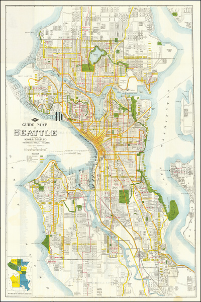
1924 Map of Seattle Washington – Early 20th Century Pacific Northwest City Map Depicting Streets Railways Harbors and Neighborhoods During Urban Expansion and Development
History In Your Home
1975 Map of Cook County Illinois – Detailed Map Depicting Municipalities Roads Railways Rivers and Urban Layout Reflecting Mid-20th-Century Urban Planning Demographics and Geographic Features of the Chicago Metropolitan Area
History In Your Home
1917 Ottoman Turkish Map of the Sinai and Palestine Campaign Depicting World War I Military Operations Front Lines Railways and Strategic Positions in the Middle Eastern Theater
History In Your Home
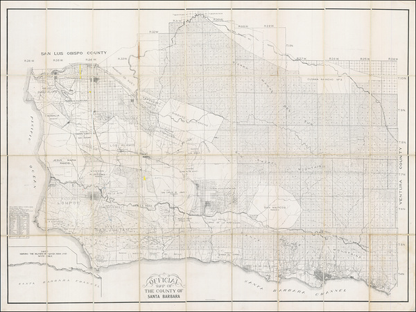
1910 Map of Santa Barbara County California – Detailed Early 20th Century Map Depicting Santa Barbara County with Towns Roads Railways Topography Land Ownership Agricultural Areas and Coastal Features Along the California Coast
History In Your Home
1910 Map of the City of Des Moines Iowa – Early 20th Century Urban Development Map Showing Street Layout Railways Parks and Neighborhoods During a Period of Growth in Iowa’s Capital City
History In Your Home
1923 Map of Palm Beach County Florida – Early 20th Century Map Depicting Towns Roads Railways and Coastal Development During Florida’s Land Boom and Early Suburban Growth
History In Your Home
1901 Map of New Zealand South Island Te Waipounamu – Detailed Colonial-Era Map Depicting Mountains Rivers Settlements and Railways Reflecting Geographic Exploration Infrastructure and Regional Development in Australasia
History In Your Home
1886 Map of Germany Under the Imperial German Empire—Detailing States Railways and Political Divisions During the Reign of Kaiser Wilhelm I in Unified Post-1871 Germany
History In Your Home
1912 Map of Atlanta Georgia – Early 20th Century Map Illustrating Atlanta with Streets Railways Parks Neighborhoods Landmarks Topography Urban Development and Municipal Planning Features
History In Your Home
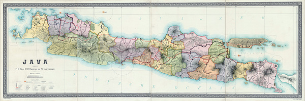
1895 Dutch Map of Java Depicting Colonial Districts Railways and Plantations Under the Dutch East Indies Government During the Height of European Imperial Expansion in Asia
History In Your Home
1936 Political and Geographic Map of Iraq – Depicting Provincial Borders Railways Major Cities and British Influence Following the Establishment of the Kingdom of Iraq During the Interwar Period
History In Your Home
6
1912 Map of Trinidad – British Colonial-Era Caribbean Map Showing Towns Railways Topographic Features and Coastline During Early 20th Century Resource and Infrastructure Development
History In Your Home
1910 Imperial Japanese Map of Korea – Late Joseon and Annexation Era Geography Showing Provincial Boundaries Cities Railways Ports and Administrative Divisions at the Dawn of Japanese Rule
History In Your Home
1884 Historical Map of the Russian Empire – Imperial-Era Map Showing Provinces Railways Ethnic Regions Major Cities Trade Routes Rivers and Expansive Territorial Boundaries Across Eastern Europe and Northern Asia
History In Your Home
1935 Road Map of Long Island Showing Highways Railways and Regional Development During the Early Automotive Age in New Yorks Expanding Suburban Corridor
History In Your Home
1929 Map of Brazil – Vintage Interwar Period South America Map Depicting States Rivers Railways and Geographic Features During a Time of National Growth and Change
History In Your Home
Print One
Plant One
One tree planted for every print.
Pictorem supports Trees for the Future, a 501(c)3 non-profit organization, that operates an agroforesty program to restore trees to degraded lands by working with smallholder farmers.
MORE INFO
EMAIL
PASSWORD
CREATE AN ACCOUNT
FORGOT YOUR PASSWORD?
×
CREATE ACCOUNT
USERNAME
EMAIL
PASSWORD
CONFIRM PASSWORD
ALREADY HAVE AN ACCOUNT?
FORGOT YOUR USER ACCOUNT DETAILS?
USERNAME OR EMAIL
AAH, WAIT, I REMEMBER NOW!
×
TOP
Send
Please wait...