Free Shipping in Continental USA & Canada -
No Extra fees
LOGIN
EN |
FR
FRANCAIS
$
FORMATS & PRICES
ART GALLERY
ABOUT US
TOOLS
SUPPORT
PRO & ARTISTS
CONTACT US
HOME
COLLECTION
SCENIC
AI WALL ART GENERATOR
LIFESTYLE
BEST SELLERS
LANDSCAPES
VINTAGE POSTERS
1X COLLECTION
BOTANICAL
MINIMALISM
OLD MASTERS & POPULAR PAINTING
WILDLIFE
CITYSCAPES
TYPOGRAPHY
POP
STYLES
ABSTRACT
AI
AIGALLERY
DRAWINGS-ABSTRACT
DRAWINGS-FINEART
DRAWINGS-GRAFFITI
DRAWINGS-ILLUSTRATION
PAINTING
PHOTOGRAPHY-ABSTRACT
PHOTOGRAPHY-LANDSCAPE
PHOTOGRAPHY-PORTRAIT
PHOTOGRAPHY-SURREALISM
VINTAGE-POSTERS
FEATURED
BEST SELLERS
EXPLORE
ROOMS
Bar
Basement
Bathroom
Bedroom
Dining Room
Game Room
Garage
Gym
Hallway
Kid's room
Kitchen
Living room
Nursery
Office
ARTISTS
SELL YOUR ART
MY CART
View Cart
Checkout
COLLECTION
STYLES
FEATURED
TOP SALES
EXPLORE
ROOMS
ARTISTS
SELL
SCENIC
AI WALL ART GENERATOR
LIFESTYLE
BEST SELLERS
LANDSCAPES
VINTAGE POSTERS
1X COLLECTION
BOTANICAL
MINIMALISM
OLD MASTERS & POPULAR PAINTING
WILDLIFE
CITYSCAPES
TYPOGRAPHY
POP
Bar
Basement
Bathroom
Bedroom
Dining Room
Game Room
Garage
Gym
Hallway
Kid's room
Kitchen
Living room
Nursery
Office
ABSTRACT
AI
AIGALLERY
DRAWINGS-ABSTRACT
DRAWINGS-FINEART
DRAWINGS-GRAFFITI
DRAWINGS-ILLUSTRATION
PAINTING
PHOTOGRAPHY-ABSTRACT
PHOTOGRAPHY-LANDSCAPE
PHOTOGRAPHY-PORTRAIT
PHOTOGRAPHY-SURREALISM
VINTAGE-POSTERS
Collection
by Style
by Shape
by Color
by Room
Artists
COLLECTION
Scenic
AI Wall Art Generator
Lifestyle
Best Sellers
Landscapes
Vintage Posters
1X Collection
Botanical
Minimalism
Old Masters & Popular painting
Wildlife
Cityscapes
Typography
Pop
Filter by Style
Abstract
(119.2k)
Ai
(84.2k)
AIGALLERY
(29.2k)
drawings-abstract
(19.5k)
drawings-fineart
(25k)
drawings-graffiti
(2.6k)
drawings-illustration
(57.8k)
painting
(232k)
photography-abstract
(38.4k)
photography-landscape
(306.9k)
photography-portrait
(38.2k)
photography-surrealism
(21.3k)
Vintage-Posters
(51k)
Filter by Shape
Landscape
Panoramic
Vertical
Square
Filter by Color
Filter by Room
Bar
Basement
Bathroom
Bedroom
Dining Room
Game Room
Garage
Gym
Hallway
Kid's room
Kitchen
Living room
Nursery
Office
Art Selection for Resellers
sort by:
Featured
Most Popular
Most Liked
Most Recent
Keyword: EUROPE
×
17th Century Dutch Map of Europe – Elaborate Early Modern European Map with Political Divisions Cities Rivers Mountains and Iconographic Allegories Typical of Dutch Cartography
History In Your Home
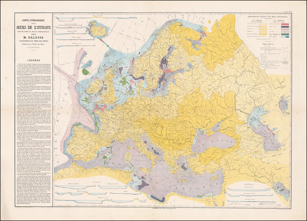
1872 Geological Map of Europe – Comprehensive 19th Century Survey Showing Continental Rock Formations Tectonic Zones and Early Scientific Understanding of European Geology
History In Your Home
Pictorial Map of Europe Featuring National Icons Regional Traditions Historic Landmarks and Illustrated Cultural Symbols Depicting Continental Unity and Identity in a Stylized Format
History In Your Home
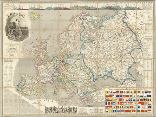
1816 Map of Europe – Post-Napoleonic Map Showing National Borders Kingdoms Empires Trade Routes Major Cities Rivers and the Redefined Political Landscape Following the Congress of Vienna
History In Your Home
21
1880 Map of Europe During the Third Crusade – Historic Medieval Campaign Map Reproduction | Political Borders & Routes of Crusader Kingdoms and Christian-European Alliances
History In Your Home
1938 German Nazi Propaganda Map of Europe – Pre-WWII Map Promoting Nazi Expansionist Ideology with Emphasis on Territorial Claims Nationalism and Germanic Unity Across the Continent
History In Your Home
12
A.P.Polo - Nord Stream
A P Polo
1592 Ortelius Map of Celtic Europe – Early Renaissance Map Illustrating Ancient Celtic Tribes Roman Conquests and Historical Regions Across Western Europe by Cartographer Abraham Ortelius
History In Your Home
1626 John Speed Map of Europe Featuring Rich Decorative Borders Coat of Arms Portraits of Monarchs and Early Seventeenth Century Territorial Borders of the Major Kingdoms and Empires of Europe
History In Your Home
1857 Map of Europe – Mid-19th Century Political Map Depicting the Nations Borders and Capitals of Europe Before Italian and German Unification Illustrating the Continent’s Complex Imperial Geography
History In Your Home
1712 Herman Moll Map of the Holy Roman Empire – Political Cartography of Central Europe’s Complex Feudal Territories During the Early 18th Century Germanic Confederation
History In Your Home
6
Holocaust Map of Europe 1938–1945 – Stark Demographic Visualization Showing Jewish Populations Before and After World War II Across Europe and the Impact of Nazi Extermination Policies
History In Your Home
1918 Peace Map of Europe – Post-World War I Vision of European Reconstruction Reflecting Hopes New Borders and Political Redefinition Following the Treaty of Versailles
History In Your Home
1593 Decorative Map of the Holy Roman Empire Featuring Imperial Borders Principalities and Heraldic Elements Reflecting the Fragmented Nature of Central Europe in the Late Renaissance Era
History In Your Home
1595 Map of Europe by Abraham Ortelius – Renaissance Map Depicting the Political and Geographic Boundaries of European Kingdoms Rivers and Cities Showcasing Ortelius’ Mastery of Early Modern Cartography and Classical Geography
History In Your Home
1915 Military Map of Europe – World War I Era Map Depicting Frontlines Political Borders and Key Battle Regions During the Great War Across Central and Eastern Europe
History In Your Home
1792 Postal Map of the Habsburg Empire – Vintage Imperial-Era Reproduction Showing Roads Cities and Mail Routes Across Central Europe Under Austrian Rule Before the Rise of Nationalism
History In Your Home
10
1813 Map of the First French Empire – Historic Cartographic Depiction of Napoleon’s Europe at the Height of Imperial Expansion | Vintage Map Showing Borders Alliances and Occupied Territories
History In Your Home
1883 Map of Romania – Historic 19th Century Eastern Europe Map Reproduction | Political Boundaries Provinces & Railways in the Kingdom of Romania During Its Early National Period
History In Your Home
12
Map of Europe Under Emperor Charles V – 16th Century Holy Roman Empire Map Showing Imperial Territories European Borders and Political Power in the Age of Reformation
History In Your Home
1952 Map of Liechtenstein Showing Post-War Political Boundaries Municipal Divisions and Alpine Geography in Mid-20th Century Central Europe
History In Your Home
6
1968 Map of Belgium – Cold War-Era Political and Transportation Chart Showing Provinces Roadways and Economic Infrastructure in One of Western Europe’s Key NATO Members
History In Your Home
6
1670 Map of the Holy Roman Empire – Early Modern European Political Map Showing Principalities Ecclesiastical Territories and Imperial Borders Prior to the Rise of Nation-States
History In Your Home
6
1816 Map of France and Western Europe – Post-Napoleonic Territorial Realignment Following the Congress of Vienna Depicting Kingdom Borders Restored Monarchies and Political Shifts
History In Your Home
1829 European Dynasty Map Illustrating Royal Families Political Alliances and Monarchies in the Aftermath of the Napoleonic Wars and During the Era of Restored Monarchic Rule Across the Continent
History In Your Home
1920 Map of Slovakia Showing Ethnic Regions Mountainous Terrain and Administrative Borders Following the Formation of Czechoslovakia After World War I
History In Your Home
1730 Wall Map of Europe Commissioned by Louis XV Showing Political Borders Kingdoms and Empires at the Height of the Ancien Regime in Pre-Revolutionary France
History In Your Home
Historical Map of Charlemagne’s Carolingian Empire Showing Extent of Territories Imperial Capitals and Cultural Influence Across Europe in the Early Middle Ages
History In Your Home
Snowy Christmas Village Scene in Old World Europe
Shelia Hunt Photography
1794 Map of Germany – Late 18th Century Map Depicting the German States Rivers and Borders of the Holy Roman Empire Highlighting the Complex Political Geography of Central Europe Before Unification
History In Your Home
1919 Map of Europe Following the Treaty of Versailles – Post World War I Political Map Depicting New National Borders Empires Dissolution and Emerging Nations in Europe
History In Your Home
11
1940 Map of Yugoslavia – Historical Balkan Peninsula Chart Depicting National Boundaries Ethnic Divisions and Regions on the Eve of World War II and Axis Invasion
History In Your Home
6
1870 Map of the Kingdom of Bohemia – Vintage Austro-Hungarian Empire Map Depicting Political Borders Cities Districts and Mountain Ranges in 19th Century Central Europe
History In Your Home
6
1617 Leo Belgicus Map of the Low Countries – Historic Allegorical Map of the Netherlands in the Shape of a Lion | Early 17th Century European Symbolic Cartography of the Dutch Revolt
History In Your Home
6
1810 Map of the Confederation of the Rhine – Napoleonic-Era Map of German States Aligned with France | Historic Cartography of Napoleon’s German Allies During Early 19th Century European Reorganization
History In Your Home
6
1926 Map of Latvia – Interwar Political Map Showing Latvia’s National Borders Cities and Infrastructure Following Independence After World War I
History In Your Home
6
1965 Map of Belgium Depicting Post-War Political Boundaries Provincial Divisions and Infrastructure in Mid-20th Century Western Europe
History In Your Home
1920 Map of Czechoslovakia – Post-World War I National Map Depicting the Newly Formed State with Cities Borders and Ethnic Regions
History In Your Home
6
1822 Geological Map of Hungary and Transylvania – Early Scientific Survey Depicting Mountain Ranges Mineral Deposits and Topographic Features in Central and Eastern Europe
History In Your Home
1705 Nicolas De Fer Map of the Holy Roman Empire – Early 18th Century French Cartographers Political Map Detailing Electorates Kingdoms and Ecclesiastical States of Central Europe
History In Your Home
1942 Map of Nazi Germany – Wartime Map Showing Administrative Boundaries Occupied Territories and Infrastructure of the Third Reich at the Height of World War II
History In Your Home
6
1914 Pictorial Map of Europe – Satirical and Nationalistic Representations of European Powers and Borders on the Eve of World War I Reflecting Political Alliances and Military Tensions
History In Your Home
Print One
Plant One
One tree planted for every print.
Pictorem supports Trees for the Future, a 501(c)3 non-profit organization, that operates an agroforesty program to restore trees to degraded lands by working with smallholder farmers.
MORE INFO
EMAIL
PASSWORD
CREATE AN ACCOUNT
FORGOT YOUR PASSWORD?
×
CREATE ACCOUNT
USERNAME
EMAIL
PASSWORD
CONFIRM PASSWORD
ALREADY HAVE AN ACCOUNT?
FORGOT YOUR USER ACCOUNT DETAILS?
USERNAME OR EMAIL
AAH, WAIT, I REMEMBER NOW!
×
TOP
Send
Please wait...