Free Shipping in Continental USA & Canada -
No Extra fees
LOGIN
EN |
FR
FRANCAIS
$
FORMATS & PRICES
ART GALLERY
ABOUT US
TOOLS
SUPPORT
PRO & ARTISTS
CONTACT US
HOME
COLLECTION
SCENIC
AI WALL ART GENERATOR
LIFESTYLE
BEST SELLERS
LANDSCAPES
VINTAGE POSTERS
1X COLLECTION
BOTANICAL
MINIMALISM
OLD MASTERS & POPULAR PAINTING
WILDLIFE
CITYSCAPES
TYPOGRAPHY
POP
STYLES
ABSTRACT
AI
AIGALLERY
DRAWINGS-ABSTRACT
DRAWINGS-FINEART
DRAWINGS-GRAFFITI
DRAWINGS-ILLUSTRATION
PAINTING
PHOTOGRAPHY-ABSTRACT
PHOTOGRAPHY-LANDSCAPE
PHOTOGRAPHY-PORTRAIT
PHOTOGRAPHY-SURREALISM
VINTAGE-POSTERS
FEATURED
BEST SELLERS
EXPLORE
ROOMS
Bar
Basement
Bathroom
Bedroom
Dining Room
Game Room
Garage
Gym
Hallway
Kid's room
Kitchen
Living room
Nursery
Office
ARTISTS
SELL YOUR ART
MY CART
View Cart
Checkout
COLLECTION
STYLES
FEATURED
TOP SALES
EXPLORE
ROOMS
ARTISTS
SELL
SCENIC
AI WALL ART GENERATOR
LIFESTYLE
BEST SELLERS
LANDSCAPES
VINTAGE POSTERS
1X COLLECTION
BOTANICAL
MINIMALISM
OLD MASTERS & POPULAR PAINTING
WILDLIFE
CITYSCAPES
TYPOGRAPHY
POP
Bar
Basement
Bathroom
Bedroom
Dining Room
Game Room
Garage
Gym
Hallway
Kid's room
Kitchen
Living room
Nursery
Office
ABSTRACT
AI
AIGALLERY
DRAWINGS-ABSTRACT
DRAWINGS-FINEART
DRAWINGS-GRAFFITI
DRAWINGS-ILLUSTRATION
PAINTING
PHOTOGRAPHY-ABSTRACT
PHOTOGRAPHY-LANDSCAPE
PHOTOGRAPHY-PORTRAIT
PHOTOGRAPHY-SURREALISM
VINTAGE-POSTERS
Collection
by Style
by Shape
by Color
by Room
Artists
COLLECTION
Scenic
AI Wall Art Generator
Lifestyle
Best Sellers
Landscapes
Vintage Posters
1X Collection
Botanical
Minimalism
Old Masters & Popular painting
Wildlife
Cityscapes
Typography
Pop
Filter by Style
Abstract
(119.2k)
Ai
(84.2k)
AIGALLERY
(29.2k)
drawings-abstract
(19.5k)
drawings-fineart
(25k)
drawings-graffiti
(2.6k)
drawings-illustration
(57.8k)
painting
(232k)
photography-abstract
(38.4k)
photography-landscape
(306.9k)
photography-portrait
(38.2k)
photography-surrealism
(21.3k)
Vintage-Posters
(51k)
Filter by Shape
Landscape
Panoramic
Vertical
Square
Filter by Color
Filter by Room
Bar
Basement
Bathroom
Bedroom
Dining Room
Game Room
Garage
Gym
Hallway
Kid's room
Kitchen
Living room
Nursery
Office
Art Selection for Resellers
sort by:
Featured
Most Popular
Most Liked
Most Recent
Keyword: Counties
×
6
1868 Map of San Mateo County California – Historic Bay Area Cartography | Vintage 19th Century California Map Featuring Townships Coastline Roads & Early Infrastructure
History In Your Home
1626 John Speed Map of England Showing Historic Counties Principal Cities and Royal Coats of Arms During the Stuart Monarchy in Early Modern Britain
History In Your Home
1923 Political Map of Northern Ireland Showing Counties Cities and Borders Following the Partition of Ireland and Creation of the United Kingdom’s Northern Territory
History In Your Home
Lake Marion Bridge Sunset
Norma Brandsberg Photography
6
1929 Historical Map of New York State – Vintage Early 20th Century Map Depicting Counties Cities Railroads and Topography Across New York During a Period of Political and Geographic Detail
History In Your Home
6
1856 Map of Illinois – Historic Mid-19th Century U.S. State Map Reproduction | Vintage Cartography Featuring Counties Rivers Railroads & Early Development
History In Your Home
1917 Map of South Dakota – Historical Map Showing Counties Cities Roads and Railroads in the American Midwest During the Progressive Era
History In Your Home
1610 Map of England – John Speed’s Iconic Tudor-Era Map Depicting Counties Cities and Heraldry in the Kingdom of England During the Reign of James I
History In Your Home
Petrified forest national park WPA BW
patrimonio
9
Princeville Prince Frederick Church Ruins
Norma Brandsberg Photography
1626 John Speed Map of Ireland – Early 17th-Century Map Depicting Counties Towns Rivers and Coastlines Reflecting Historical Geography Cartographic Techniques and European Knowledge of Ireland During the Stuart Period
History In Your Home
1891 Map of Alabama – Post-Reconstruction Era Survey Depicting Counties Railroads and Infrastructure During a Period of Economic Transition and Industrial Development in the American South
History In Your Home
Irish Gaelic Map of Ireland Showing Place Names in Native Language—Preserving Linguistic Heritage and Cultural Identity Across Ireland’s Historical Provinces and Counties
History In Your Home
1880 Map of Quebec Province Canada – Detailed 19th-Century Map Depicting Counties Towns Rivers Roads and Geography Reflecting Political Boundaries Settlement Patterns and Economic Development in Eastern Canada
History In Your Home
1866 Map of Michigan – Post-Civil War State Map Depicting Railroads Counties and Population Centers Across the Upper and Lower Peninsulas
History In Your Home
6
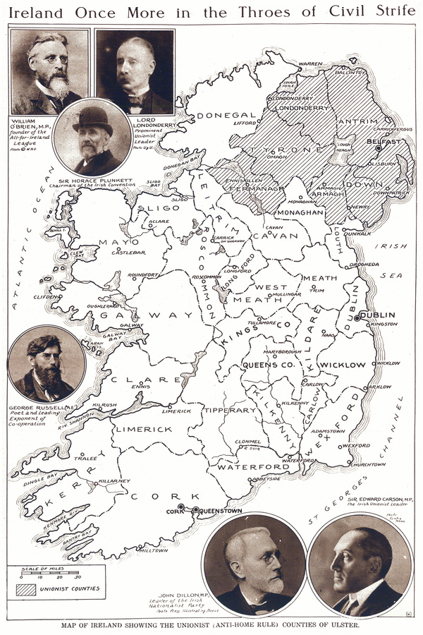
1918 Political Map of Ireland – Historic Chart Showing Irish Counties Parliamentary Boundaries and Nationalist Movements During the Irish War of Independence Era
History In Your Home
1860 Map of California – Mid-19th Century Cartography Depicting Counties Cities Rivers Roads and Topography Reflecting Geographic Knowledge and Development of California Shortly After Statehood
History In Your Home
1888 Map of Wyoming Showing Counties Railroads and Topographic Features as the Territory Approached Statehood
History In Your Home
1890 Arthur Ide Map of Montana Showing Counties Railroads Indian Reservations and Topography During Western Expansion and Early Statehood
History In Your Home
1826 John Melish Map of Pennsylvania – Detailed Early 19th-Century Map Depicting Counties Towns Rivers Roads and Topography Reflecting Geographic Knowledge Cartography and Settlement Patterns in the Keystone State
History In Your Home
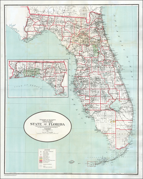
1923 General Land Office Map of Florida – Official U.S. Government Map Showing Counties Railroads Public Lands and Swamp Drainage Projects During the Florida Real Estate Boom of the 1920s
History In Your Home
6
1896 Map of Long Island New York – Late 19th Century Map Detailing Counties Towns Railroads and Coastline During a Period of Suburban Growth and Industrial Expansion in the Northeast
History In Your Home
1886 Map of Southern California – Regional Map Depicting Counties Cities Railroads and Topography Reflecting Population Growth Economic Development and the Expansion of Transportation Networks in Late 19th-Century California
History In Your Home
1610 John Speed Map of Wales – Early 17th Century Map Showing Counties Towns Rivers Castles Roads and Topography Across Wales with Historical Borders and Detailed Geographic Features
History In Your Home
6
1908 Map of the State of Utah Showing Counties Railroads and Geographic Features During Early 20th Century Development
History In Your Home
1867 Map of New Brunswick Canada Showing Counties Settlements and Transportation Routes During the Early Confederation Era of Canadian Maritime Development
History In Your Home
1808 Map of the Kingdom of Hungary – Early 19th-Century Habsburg-Era Territorial Map Showing Counties Rivers Cities Political Divisions and Geographic Features Across Historic Central Europe
History In Your Home
6
1915 Prohibition Map of the United States – Illustrating Dry and Wet Counties Prior to the 18th Amendment Reflecting Growing Temperance Movement and the Regional Divide Over Alcohol Laws
History In Your Home
6
1919 Wet and Dry Prohibition Map of the United States – Temperance Era Map Showing “Wet” vs “Dry” States Before the Ratification of the 18th Amendment and National Prohibition
History In Your Home
1834 Map of New York State – Early 19th-Century Regional Map Depicting Counties Towns Transportation Routes Rivers Canals and Expanding Infrastructure Across the Empire State
History In Your Home
1914 Map of Missouri – Detailed State Map Showing Counties Railroads Rivers and Roadways as Missouri Transitioned into a Modern Industrial and Agricultural Hub in Early 20th Century America
History In Your Home
1816 Map of New Hampshire – Early 19th-Century Map Depicting Counties Towns Rivers and Roads Reflecting Geographic Knowledge Regional Development and Cartographic Practices in the Post-Revolutionary United States
History In Your Home
1796 Map of Virginia – Late 18th Century Map Depicting Virginia’s Counties Towns Rivers Roads and Topography Reflecting Political and Geographic Divisions During the Post-Revolutionary Era
History In Your Home
1883 Map of Dakota Territory Showing Counties Railroads and Settlements Prior to the Statehood of North and South Dakota
History In Your Home
1801 Map of Massachusetts Showing Towns Counties and Geographic Features During the Early Federal Period of American Nation-Building
History In Your Home
6
1858 Map of the Counties of Barnstable Dukes and Nantucket Massachusetts – Historic Cape Cod & Islands Map Reproduction | Coastal New England Cartography
History In Your Home
1889 Map of the State of Washington – Late 19th-Century Topographical and Political Map Showing Counties Towns Rivers Mountains Railroads and Settlement Patterns During the Year Washington Achieved Statehood
History In Your Home
6
Historical Map of England and Wales Showing Ancient Counties Cathedral Towns Rivers Mountains and Important Roads Prior to Modern Unification and Industrialization in the British Isles
History In Your Home
1801 Map of New York State – Early 19th-Century Map Depicting Counties Towns Rivers and Roads Reflecting Post-Revolutionary Cartography Settlement Patterns and Geographic Knowledge in the Empire State
History In Your Home
1859 Map of the State of Georgia – Antebellum Era Cartography Showing Georgia’s Counties Towns Roads Rivers and Geographic Features
History In Your Home
1579 Christopher Saxton Map of England and Wales – Landmark Tudor Atlas Map Showing Counties Rivers and Early Political Boundaries
History In Your Home
1856 La Tourrette Map of Alabama and West Florida Showing Railroads Rivers Counties and Infrastructure Prior to the Civil War in the American South
History In Your Home
Print One
Plant One
One tree planted for every print.
Pictorem supports Trees for the Future, a 501(c)3 non-profit organization, that operates an agroforesty program to restore trees to degraded lands by working with smallholder farmers.
MORE INFO
EMAIL
PASSWORD
CREATE AN ACCOUNT
FORGOT YOUR PASSWORD?
×
CREATE ACCOUNT
USERNAME
EMAIL
PASSWORD
CONFIRM PASSWORD
ALREADY HAVE AN ACCOUNT?
FORGOT YOUR USER ACCOUNT DETAILS?
USERNAME OR EMAIL
AAH, WAIT, I REMEMBER NOW!
×
TOP
Send
Please wait...