Free Shipping in Continental USA & Canada -
No Extra fees
LOGIN
EN |
FR
FRANCAIS
$
FORMATS & PRICES
ART GALLERY
ABOUT US
TOOLS
SUPPORT
PRO & ARTISTS
CONTACT US
HOME
COLLECTION
SCENIC
AI WALL ART GENERATOR
LIFESTYLE
BEST SELLERS
LANDSCAPES
VINTAGE POSTERS
1X COLLECTION
BOTANICAL
MINIMALISM
OLD MASTERS & POPULAR PAINTING
WILDLIFE
CITYSCAPES
TYPOGRAPHY
POP
STYLES
ABSTRACT
AI
AIGALLERY
DRAWINGS-ABSTRACT
DRAWINGS-FINEART
DRAWINGS-GRAFFITI
DRAWINGS-ILLUSTRATION
PAINTING
PHOTOGRAPHY-ABSTRACT
PHOTOGRAPHY-LANDSCAPE
PHOTOGRAPHY-PORTRAIT
PHOTOGRAPHY-SURREALISM
VINTAGE-POSTERS
FEATURED
BEST SELLERS
EXPLORE
ROOMS
Bar
Basement
Bathroom
Bedroom
Dining Room
Game Room
Garage
Gym
Hallway
Kid's room
Kitchen
Living room
Nursery
Office
ARTISTS
SELL YOUR ART
MY CART
View Cart
Checkout
COLLECTION
STYLES
FEATURED
TOP SALES
EXPLORE
ROOMS
ARTISTS
SELL
SCENIC
AI WALL ART GENERATOR
LIFESTYLE
BEST SELLERS
LANDSCAPES
VINTAGE POSTERS
1X COLLECTION
BOTANICAL
MINIMALISM
OLD MASTERS & POPULAR PAINTING
WILDLIFE
CITYSCAPES
TYPOGRAPHY
POP
Bar
Basement
Bathroom
Bedroom
Dining Room
Game Room
Garage
Gym
Hallway
Kid's room
Kitchen
Living room
Nursery
Office
ABSTRACT
AI
AIGALLERY
DRAWINGS-ABSTRACT
DRAWINGS-FINEART
DRAWINGS-GRAFFITI
DRAWINGS-ILLUSTRATION
PAINTING
PHOTOGRAPHY-ABSTRACT
PHOTOGRAPHY-LANDSCAPE
PHOTOGRAPHY-PORTRAIT
PHOTOGRAPHY-SURREALISM
VINTAGE-POSTERS
Collection
by Style
by Shape
by Color
by Room
Artists
COLLECTION
Scenic
AI Wall Art Generator
Lifestyle
Best Sellers
Landscapes
Vintage Posters
1X Collection
Botanical
Minimalism
Old Masters & Popular painting
Wildlife
Cityscapes
Typography
Pop
Filter by Style
Abstract
(119k)
Ai
(84k)
AIGALLERY
(29k)
drawings-abstract
(19.5k)
drawings-fineart
(25k)
drawings-graffiti
(2.6k)
drawings-illustration
(57.8k)
painting
(231.2k)
photography-abstract
(38.4k)
photography-landscape
(305.4k)
photography-portrait
(38.4k)
photography-surrealism
(21.2k)
Vintage-Posters
(50.9k)
Filter by Shape
Landscape
Panoramic
Vertical
Square
Filter by Color
Filter by Room
Bar
Basement
Bathroom
Bedroom
Dining Room
Game Room
Garage
Gym
Hallway
Kid's room
Kitchen
Living room
Nursery
Office
Art Selection for Resellers
sort by:
Featured
Most Popular
Most Liked
Most Recent
Keyword: Colonies
×
1673 Map of the British Colonies in America – Early Colonial Map Showing the Atlantic Coast Settlements and Native Territories Reflecting 17th-Century Exploration and the Expansion of England’s New World Colonies
History In Your Home
6
1673 First Proprietary Map of Carolina – Early Colonial American Chart Commissioned by the Lords Proprietors Showing British Settlements Indigenous Lands and Coastlines in the Restoration Era
History In Your Home
1835 Map of the Virgin Islands Depicting Colonial Holdings Trade Ports Topographical Features and Maritime Routes in the Caribbean During the Era of European Imperial Expansion in the West Indies
History In Your Home
1818 Map of Paramaribo Suriname Showing Dutch Colonial Layout River Access and Plantation Zones During the Height of Sugar Trade in the Guianas
History In Your Home
17th Century Blaeu Map of Dutch and British Colonies in North America – Detailed Early Modern Map Showing Settlements Rivers Trade Routes Coastal Features and Territorial Claims of Dutch and British Colonies
History In Your Home
Map of The American Colonies and Canada, showing the British Forts in 1755. From The Story of England, published 1930.
PacificStock
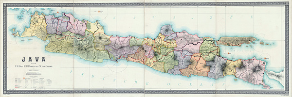
1895 Dutch Map of Java Depicting Colonial Districts Railways and Plantations Under the Dutch East Indies Government During the Height of European Imperial Expansion in Asia
History In Your Home
1671 Lord Baltimore Map of Maryland – Colonial Chesapeake Bay Map Depicting Early English Settlements Rivers and Provincial Boundaries in the Mid-Atlantic Colonies
History In Your Home
1779 First Printed Map to Name the United States – Revolutionary Era Map Detailing Thirteen Colonies Early State Boundaries Major Cities Rivers Topography and Colonial Geography in America
History In Your Home
6
1710 English Wall Map of North America – Historic Early 18th Century Colonial Territories Map Reproduction | British Imperial Cartography Showing Settlements Rivers & Borders Pre-Independence
History In Your Home
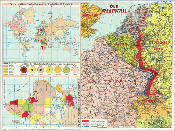
1940 German Military Map of African Colonies – Nazi-Era Colonial Projection Showing Former Imperial Holdings Territorial Ambitions and Strategic Interests Across the African Continent
History In Your Home
1748 Map of the Colony of Georgia the Earliest Obtainable Edition Depicting British Colonial Settlements Coastal Forts and the Southeastern U.S. Frontier During the Colonial Era
History In Your Home
1720 Map of Colonial North America – Early 18th Century Map Depicting British French and Spanish Claims Settlements and Territorial Divisions Prior to American Independence
History In Your Home
Mission of the mars
Point Art
1928 Map of Chubut Province Argentina Showing Settlements Rivers Railways and Welsh Colonies in the Patagonian Region During the Early 20th Century
History In Your Home
1957 Map of Cayenne French Guiana Showing Colonial Districts Administrative Borders and Coastal Settlements During the Final Decades of French Overseas Governance
History In Your Home
6
1950 Map of French Guiana – Mid-20th Century Colonial-Era Map of South America’s French Overseas Territory Featuring Geography Settlements & Borders
History In Your Home
1687 Map of Pennsylvania – Early Colonial Map Depicting Rivers Settlements and Territories of William Penn’s Province Highlighting Indigenous Lands and Early European Exploration of North America
History In Your Home
18th Century Map of Saint Vincent Island in the Caribbean Showing European Colonial Claims Settlements Terrain and Coastal Fortifications During the Age of Exploration
History In Your Home
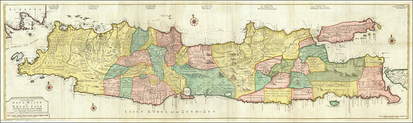
1728 Dutch Map of Java Showing Colonial Settlements Fortifications and Topography During the VOC Period of Dutch East Indies Rule in Southeast Asia
History In Your Home
147
1914 Flag Chart for the British Empire Featuring Flags of Colonies Dominions and Protectorates on the Eve of World War I
History In Your Home
1655 Map of the New Sweden Colony in America – Early Colonial-Era Map Depicting Swedish Settlements Native Territories River Systems Forts Trade Routes and the Delaware Valley During Scandinavian Expansion in North America
History In Your Home
1764 Map of Boston Massachusetts – Colonial American Map Depicting Harbor Fortifications Early Streets and Landmarks Before the American Revolution
History In Your Home
1917 Map of Vanuatu – Early 20th-Century Map of the New Hebrides Archipelago Showing Islands Reefs and Settlements Reflecting Colonial Exploration and South Pacific Geography During the World War I Era
History In Your Home
1775 Fry-Jefferson Map of Virginia and Maryland Depicting Colonial Settlements Rivers and County Lines Prior to the American Revolution in British North America
History In Your Home
1779 Revolutionary War Map of New Jersey and New York – Continental Army Campaigns and Battle Locations During the American Struggle for Independence
History In Your Home
6
1733 Popple Map of North America – Monumental British Map Depicting Spanish and British Colonial Claims Indigenous Territories and Early 18th Century Boundaries in the Americas
History In Your Home
9
Glossy Anhinga Florida Bird
Norma Brandsberg Photography
1681 Thomas Holme Map of Pennsylvania – Original William Penn Colonial Map Depicting Early Philadelphia Quaker Settlements and Land Divisions in the Province of Pennsylvania
History In Your Home
1778 Map of Dominica – Late 18th-Century Map Depicting Mountainous Terrain Rivers Plantations and Settlements of the Caribbean Island Reflecting French and British Colonial Control During the Age of Empire
History In Your Home
1915 Map of Sint Maarten Showing Towns Bays and Divisions of the Dutch–French Caribbean Island During Early 20th Century Colonial Rule
History In Your Home
1839 Map of Van Diemen’s Land Now Tasmania Illustrating Penal Colonies Mountainous Terrain Settlements and Coastlines Under British Colonial Rule During the Early 19th Century in Australia
History In Your Home
10
Anhinga Sunning My Wings
Norma Brandsberg Photography
1775 Map of the Mississippi River – Colonial-Era River Survey Depicting Channels Settlements Forts Trade Routes and Strategic Waterways From the Upper Valley to the Gulf During Pre-Revolutionary America
History In Your Home
1794 Map of the Virgin Islands – Detailed 18th-Century Caribbean Map Depicting British Danish and French Territories Islands and Navigation Routes Reflecting Colonial Trade and Maritime Exploration
History In Your Home
1862 Map of Australia Showing Colonial Boundaries Settlements and Inland Explorations During the Early Period of British Occupation
History In Your Home
1839 Map of Tasmania Depicting British Penal Colonies Early Settlements Rugged Terrain and Coastal Topography During the Early Years of British Expansion in Australia
History In Your Home
1776 Revolutionary War Map of New England Showing British Colonies at the Outset of the American War for Independence Featuring Key Colonial Territories and Conflict Zones
History In Your Home
8
Jamestown Church Colonial Governors Plaque
Norma Brandsberg Photography
Daniel Francis Schas [1772–1848]. Member of the Council for Commerce and the Colonies from 1814 to 1820 [1826] by Alexandre–Jean Dubois–Drahonet [1791–1829]
MyCozyFineArt
1775 Map of Saint Vincent – Colonial Caribbean Map Depicting Plantations Rivers and Mountains of the Island Reflecting British and French Territorial Claims and the Geography of the Lesser Antilles
History In Your Home
1783 Map of North America Showing United States Independence After the American Revolution With Boundaries Recognized by the Treaty of Paris and Remaining British and Spanish Holdings
History In Your Home
Print One
Plant One
One tree planted for every print.
Pictorem supports Trees for the Future, a 501(c)3 non-profit organization, that operates an agroforesty program to restore trees to degraded lands by working with smallholder farmers.
MORE INFO
EMAIL
PASSWORD
CREATE AN ACCOUNT
FORGOT YOUR PASSWORD?
×
CREATE ACCOUNT
USERNAME
EMAIL
PASSWORD
CONFIRM PASSWORD
ALREADY HAVE AN ACCOUNT?
FORGOT YOUR USER ACCOUNT DETAILS?
USERNAME OR EMAIL
AAH, WAIT, I REMEMBER NOW!
×
TOP
Send
Please wait...


![Daniel Francis Schas [1772–1848]. Member of the Council for Commerce and the Colonies from 1814 to 1820 [1826] by Alexandre–Jean Dubois–Drahonet [1791–1829] by MyCozyFineArt](https://www.pictorem.com/uploads/collection/Q/QI1LOG8CPG/600_MyCozyFineArt_688391_Daniel_Francis_Schas_1772_1848_Member_of_the_Coun.jpg)
![Daniel Francis Schas [1772–1848]. Member of the Council for Commerce and the Colonies from 1814 to 1820 [1826] by Alexandre–Jean Dubois–Drahonet [1791–1829] by MyCozyFineArt](https://s3.pictorem.com/images/collection/Q/QI1LOG8CPG/rs_2344488.jpg)


