Free Shipping in Continental USA & Canada -
No Extra fees
LOGIN
EN |
FR
FRANCAIS
$
FORMATS & PRICES
ART GALLERY
ABOUT US
TOOLS
SUPPORT
PRO & ARTISTS
CONTACT US
HOME
COLLECTION
SCENIC
AI WALL ART GENERATOR
LIFESTYLE
BEST SELLERS
LANDSCAPES
VINTAGE POSTERS
1X COLLECTION
BOTANICAL
MINIMALISM
OLD MASTERS & POPULAR PAINTING
WILDLIFE
CITYSCAPES
TYPOGRAPHY
POP
STYLES
ABSTRACT
AI
AIGALLERY
DRAWINGS-ABSTRACT
DRAWINGS-FINEART
DRAWINGS-GRAFFITI
DRAWINGS-ILLUSTRATION
PAINTING
PHOTOGRAPHY-ABSTRACT
PHOTOGRAPHY-LANDSCAPE
PHOTOGRAPHY-PORTRAIT
PHOTOGRAPHY-SURREALISM
VINTAGE-POSTERS
FEATURED
BEST SELLERS
EXPLORE
ROOMS
Bar
Basement
Bathroom
Bedroom
Dining Room
Game Room
Garage
Gym
Hallway
Kid's room
Kitchen
Living room
Nursery
Office
ARTISTS
SELL YOUR ART
MY CART
View Cart
Checkout
COLLECTION
STYLES
FEATURED
TOP SALES
EXPLORE
ROOMS
ARTISTS
SELL
SCENIC
AI WALL ART GENERATOR
LIFESTYLE
BEST SELLERS
LANDSCAPES
VINTAGE POSTERS
1X COLLECTION
BOTANICAL
MINIMALISM
OLD MASTERS & POPULAR PAINTING
WILDLIFE
CITYSCAPES
TYPOGRAPHY
POP
Bar
Basement
Bathroom
Bedroom
Dining Room
Game Room
Garage
Gym
Hallway
Kid's room
Kitchen
Living room
Nursery
Office
ABSTRACT
AI
AIGALLERY
DRAWINGS-ABSTRACT
DRAWINGS-FINEART
DRAWINGS-GRAFFITI
DRAWINGS-ILLUSTRATION
PAINTING
PHOTOGRAPHY-ABSTRACT
PHOTOGRAPHY-LANDSCAPE
PHOTOGRAPHY-PORTRAIT
PHOTOGRAPHY-SURREALISM
VINTAGE-POSTERS
Collection
by Style
by Shape
by Color
by Room
Artists
COLLECTION
Scenic
AI Wall Art Generator
Lifestyle
Best Sellers
Landscapes
Vintage Posters
1X Collection
Botanical
Minimalism
Old Masters & Popular painting
Wildlife
Cityscapes
Typography
Pop
Filter by Style
Abstract
(119k)
Ai
(84k)
AIGALLERY
(29k)
drawings-abstract
(19.5k)
drawings-fineart
(25k)
drawings-graffiti
(2.6k)
drawings-illustration
(57.8k)
painting
(231.2k)
photography-abstract
(38.4k)
photography-landscape
(305.4k)
photography-portrait
(38.4k)
photography-surrealism
(21.2k)
Vintage-Posters
(50.9k)
Filter by Shape
Landscape
Panoramic
Vertical
Square
Filter by Color
Filter by Room
Bar
Basement
Bathroom
Bedroom
Dining Room
Game Room
Garage
Gym
Hallway
Kid's room
Kitchen
Living room
Nursery
Office
Art Selection for Resellers
sort by:
Featured
Most Popular
Most Liked
Most Recent
Keyword: Archival-Ink
×
Light Being Blue
Frank Pietronigro
Light Beings Hot
Frank Pietronigro
Light Being Pink
Frank Pietronigro
Light Being Calm
Frank Pietronigro
Light Being Radiant
Frank Pietronigro
Light Being Full
Frank Pietronigro
Light Being There
Frank Pietronigro
Light Being Gold
Frank Pietronigro
6
1877 Catholic Provinces Map of the United States – 19th Century Ecclesiastical Map Depicting Catholic Dioceses and Archdioceses During a Period of Rapid Religious Expansion in America
History In Your Home
6
1924 Map of Orlando Florida – Early 20th Century City Map Depicting Lakes Streets Railroads and Landmarks During the Rise of Orlando as a Key Urban Center in Central Florida
History In Your Home
12
1911 Military Map of the Italo-Turkish War – Early 20th Century Conflict Map Depicting Italian and Ottoman Military Positions in Libya and the Mediterranean During Imperial Expansion
History In Your Home
6
1976 Map of East Timor – Post-Independence Southeast Asia Map Depicting Political Boundaries Terrain and Settlements Following the Declaration of the Democratic Republic of Timor-Leste
History In Your Home
6
1871 Map of Chicago Fire Damage – 19th Century Disaster Map Depicting Destruction from the Great Chicago Fire Including Burnt Districts Streets and Rebuilding Efforts
History In Your Home
6
1892 Map of Petion-Ville Haiti – 19th Century Suburban Map of Port-au-Prince Showing Early Urban Planning Terrain and Streets During Haitian Post-Revolutionary Development
History In Your Home
1920 British Admiralty Map of Pearl Harbor – Early 20th Century Naval Chart Depicting Oahu’s Coastline Harbor Depths and Strategic Military Installations Before the Attack on Pearl Harbor
History In Your Home
6
1911 Map of Lesotho – Early 20th Century Southern Africa Map Depicting Mountainous Terrain Rivers and Political Borders During British Colonial Administration of Basutoland
History In Your Home
6
Aboriginal Indigenous Map of Canada – Culturally Inspired Map Depicting Traditional Territories Languages and Nations of First Peoples Across Canada in a Pre-Colonial and Historic Context
History In Your Home
6
1858 Map of Sinaloa Mexico – 19th Century Northwestern Mexico Map Depicting Mountain Ranges Settlements and Pacific Coastlines During Regional Development in the Mexican Republic
History In Your Home
6
1853 Map of the Republic of Liberia – 19th Century West African Settlement Map Depicting African-American Colonies Coastal Towns and Political Divisions in Early Independent Liberia
History In Your Home
6
1853 Map of Maryland in Liberia – 19th Century West African Map Depicting the African-American Colony on the Grain Coast During the Liberian Colonization Movement
History In Your Home
6
1919 Wet and Dry Prohibition Map of the United States – Temperance Era Map Showing “Wet” vs “Dry” States Before the Ratification of the 18th Amendment and National Prohibition
History In Your Home
6
1611 John Speed Map of Canaan – 17th Century Biblical Map Featured in the King James Bible Depicting Ancient Israel and the Holy Land with Religious Symbolism and English Renaissance Cartography
History In Your Home
6
1896 Map of Buffalo New York – Late 19th Century City Map Depicting Streets Railways Waterfront and Landmarks During a Period of Industrial Growth in Western New York
History In Your Home
6
1858 Map of Queretaro Mexico – 19th Century Central Mexico Map Showing Political Boundaries Roads Cities and Terrain During the Early Years of the Mexican Republic
History In Your Home
1720 Map of Catalonia – 18th Century Spanish Regional Map Showing Political Borders Cities and Mediterranean Coast During a Period of Conflict and Realignment in Iberian History
History In Your Home
6
1858 Map of Coahuila Mexico – 19th Century Northern Mexico Map Showing Regional Cities Terrain and Borders During National Consolidation in the Early Mexican Republic
History In Your Home
6
1918 Map of Salmon National Forest – Vintage U.S. Forest Service Map Depicting Trails Rivers Elevation and Wilderness Boundaries in Idaho’s Rugged Mountain Backcountry
History In Your Home
1892 Map of Ecuador – 19th Century Historical South America Map Depicting Post-Independence Borders Andean Terrain and National Development During the Republican Era of Ecuadorian History
History In Your Home
6
1666 Map of London After the Great Fire – 17th Century City Map Depicting Fire-Damaged Districts Rebuilding Plans and Street Layouts Following the Devastating Fire That Reshaped London
History In Your Home
6
1858 Map of Tehuantepec and Minatitlan Mexico – 19th Century Southeastern Mexico Map Showing Rivers Terrain and Strategic Geography Along the Isthmus During National Expansion
History In Your Home
6
1858 Map of Guerrero Mexico – 19th Century Southern Mexico Map Depicting Acapulco Mountainous Terrain and Pacific Coastlines During Regional Growth in the Early Republican Period
History In Your Home
6
1858 Map of Michoacan Mexico – Historic Post-Colonial Mexican State Map Showing Morelia Terrain and Regional Boundaries During the Early Nation-Building Period of 19th Century Mexico
History In Your Home
20th Century Map of Marrakesh Morocco – North African Urban Map Depicting Streets the Medina and Key Landmarks During the Colonial Period in Early Modern Moroccan History
History In Your Home
6
First Opium War Map of Eastern China – Early 19th Century Chinese Coastal Map Showing Ports Provinces and Military Zones During British-Chinese Conflict Over Trade and Sovereignty
History In Your Home
6
1858 Map of Sierra Gorda and Isla del Carmen – 19th Century Regional Mexican Maps Depicting Coastal Terrain Mountain Landscapes and Settlements in the Gulf of Mexico Region
History In Your Home
6
1892 Scientific Survey Map of Death Valley – 19th Century U.S. Geological and Topographic Map Depicting Elevation Desert Terrain and Natural Features of the American West
History In Your Home
6
1858 Map of Baja California Mexico – 19th Century Peninsula Map Depicting Coastal Geography Settlements and Arid Terrain During Regional Expansion in Post-Independence Mexico
History In Your Home
6
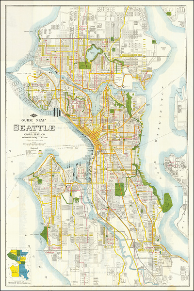
1924 Map of Seattle Washington – Early 20th Century Pacific Northwest City Map Depicting Streets Railways Harbors and Neighborhoods During Urban Expansion and Development
History In Your Home
6
1953 Map of Pakistan – Mid-20th Century Post-Independence Map Showing Provinces Cities and National Borders Following the Formation of Pakistan After the Partition of British India
History In Your Home
6
1858 Map of Aguascalientes Mexico – 19th Century Central Mexican State Map Showing Political Boundaries Terrain Rivers and Regional Urban Centers During Republican Nation-Building
History In Your Home
6
1860 Admiralty Chart of Northern Chinese Provinces – British Naval Map From the Second Opium War Depicting Coastlines Ports and Strategic Zones Along China’s Maritime Frontier
History In Your Home
1867 Map of the Empire of Brazil – 19th Century South American Imperial Map Showing Provinces Borders and River Systems During the Final Decades of the Brazilian Monarchy
History In Your Home
Print One
Plant One
One tree planted for every print.
Pictorem supports Trees for the Future, a 501(c)3 non-profit organization, that operates an agroforesty program to restore trees to degraded lands by working with smallholder farmers.
MORE INFO
EMAIL
PASSWORD
CREATE AN ACCOUNT
FORGOT YOUR PASSWORD?
×
CREATE ACCOUNT
USERNAME
EMAIL
PASSWORD
CONFIRM PASSWORD
ALREADY HAVE AN ACCOUNT?
FORGOT YOUR USER ACCOUNT DETAILS?
USERNAME OR EMAIL
AAH, WAIT, I REMEMBER NOW!
×
TOP
Send
Please wait...